2024 Sandbox Competition: Resilience in the Face of Climate Change
Competition Timeline
- Expressions of Interest due December 15, 2023. Please e-mail kdriggs@ite.org to ensure you are added to the e-mail communications.
- Project work to be done January 2-April 1, 2024
- Final Submissions are due at midnight ET on April 1, 2024, using this link.
- Two finalist teams in both the student and professional categories will be notified by April 30, 2024
- Each finalist team will be expected to send one representative to do a final presentation in Philadelphia in July for the Joint ITE International and Mid-Colonial District Annual Meeting and Exhibition. Winners will be announced during the Awards Luncheon.
Purpose:
Climate change and natural threats poses a serious threat to the well-being and livelihoods of people living in urban, suburban and/or rural areas, as they are exposed to various climate hazards that can damage their infrastructure, disrupt their services, and endanger their health and safety. Current practices of engineering, planning, and analysis may not adequately address the needs and preferences of all users in the face of climate change and may result in maladaptation or increased vulnerability. There is a need for innovative and participatory approaches that can enhance the resilience of urban (or suburban) communities and empower all users to cope with and recover from climate shocks and stresses.
As communities face the challenges and opportunities of climate change, engineers, planners, and analysts have an opportunity to enhance the resilience of the built environment for all users. Decisions on how infrastructure is designed, public spaces are adapted and how governing agencies should plan can impact a community’s ability to cope with and recover from climate hazards, such as floods, heat waves, snow/ice, tropical storms and/or wildfires.
The proposed sandbox activity includes applying a variety of strategic, programmatic, and tactical activities to improve the resilience of transportation infrastructure in response to four potential climate/naturally occurring threats: Coastal Flooding, Wildfire, Winter Storms, and Extreme Heat.
Problem Statement:
Four locations have been identified by ITE which are defined as low/moderate risks by FEMA to specific naturally occurring threats. Each team will be required to develop two (2) Resiliency Response Plans. One plan to address Threats #1 or #2; and one plan to address threats #3 or #4. The plans are expected to generally include:
- Description of the Threat and the Risk to the specified Locations as identified by ITE.
- Identification of Risk Responses for both mitigation and adaptation.
- The Engineering Methodology in developing the mitigation and adaptation strategies.
- Readiness/feasibility to implement and the ability of applying the proposed strategies systemically.
- Define the specific goals and objectives of each strategy.
- Compile the above into a technical memorandum.
The matrix on the following page outlines the threats, study locations and scenarios which require a resiliency response plan. The locations were selected using FEMA’s National Risk Index for Natural Hazards. The locations selected are considered low to moderate in risk assessment as defined by FEMA.
The four threats were selected from the potential 18 natural hazards included in the National Risk Index of FEMA. The attached links provide access to the FEMA website and Mitigation Planning Guidance.
- FEMA’s National Risk Index for Natural Hazards: https://hazards.fema.gov/nri/map
- FEMA Fact Sheet
Definitions
The term "resilience" means the ability to prepare for and adapt to changing conditions; and to withstand and recover rapidly from disruptions. Resilience includes the ability to withstand and recover from deliberate attacks, accidents, or naturally occurring threats or incidents.
The term "mitigation" can be understood as the process of designing the current infrastructure to lessen the impacts of climate change and naturally occurring threats. Mitigation will make the impacts of the risk less severe. This means the engineering or planning strategies should reduce the impact on critical infrastructure.
The term "adaptation" can be understood as the process of adjusting the current infrastructure to reduce exposure to the future effects of climate change and naturally occurring threats. This means the engineering or planning strategies will reduce the exposure of critical infrastructure to risks from natural hazards before they occur.
Challenge Parameters:
-
Prepare a plan and a design which responds to the Coastal Flooding or Wildfire Climate Risk.
- Identify and Describe the risks to the transportation system
- Prepare a plan, encompassing both mitigation and adaptation strategies at the network and community level, which respond to the risk/threat
- Prepare a conceptual design for the improvement to one (1) critical element of infrastructure (i.e., a roadway cross section, bridge cross section, intersection improvement, etc.) which responds to the risk/threat consistent with the previously selected strategies
- Demonstrate the transferability of the proposed strategies
-
Prepare mitigation and adaptation response plan and design to either the Winter Storm or Extreme Heat Climate Risk.
- Identify and Describe the risks to the transportation system
- Prepare a plan, encompassing both mitigation and adaptation strategies at a network level, which respond to the risk/threat
- Prepare a conceptual design for the improvement to one (1) critical element of infrastructure (i.e., a roadway cross section, bridge cross section, intersection improvement, etc.) to respond to the risk/threat consistent with the previously selected strategies
- Demonstrate the transferability of the proposed strategies
Description and Location
- The figures below provide a Description of the Location/Scenarios of the climate risks; and provided detailed information on the specific census tracts to consider when evaluating critical infrastructure and network responses.
Eligibility
- There will be separate professional and student categories. Cities/agencies wishing to enter would do so under the professional category.
- Teams can include an unlimited number of participants, but at least one member of the team must be an ITE member.
- Please note that if you are entering in the Student Category, each member of your team must be a full-time undergraduate or graduate student.
Evaluation of the Entries/Submissions
- The top two teams in both the professional and student categories will be invited to present their approach and solutions as part of the ITE Annual Meeting and Exhibition in Philadelphia, PA and take questions from the audience in an open and interactive session.
- Presentation guidelines will be provided to the finalists once shortlisted.
- A panel of 4-6 judges will be established by ITE
Submission Guidelines:
- Online Submission Link. Complete the contact information and upload your two Resiliency Response Plans as one PDF file.
- Each submission is limited to no more than 15 8 ½ X 11 pages including covers, graphics, and/or images.
- Submitters should use an 11x17 page to present the proposed designs of the critical elements of infrastructure.
- Submitters must detail the selected strategies and explain their application.
- Please explain the methodology and justify recommendations.
- Please be sure the Technical Memorandum includes the team methodology and transferability of applying the proposed strategies systemically to other communities.
Criteria
-
Quality of writing and presentation (20%)
-
Situation 1 (40%)
- Identification of issues, description of the problem (10%)
- Cross Section (sound planning, engineering and design, applicability, ability to address identified issues and transferability) (10%)
- Network interventions for adaptability and mitigation (sound engineering / design, applicability, ability to address identified issues and transferability) (20%)
-
Situation 2 (40%)
- Identification of issues, description of the problem (5%)
- Cross Section (sound engineering / design, applicability, ability to address identified issues and transferability) (10%)
- Network interventions for adaptability and mitigation (sound engineering / design, applicability, ability to address identified issues and transferability) (20%)
- Consideration of cooling/warming centers (5%)
Recognition
- The winning teams will be recognized at the ITE Annual Awards Luncheon in Philadelphia, PA . Press and industry announcements will be issued highlighting the finalists and winners.
- One paid full Annual Meeting registration will be provided to one representative from each of the two professional teams that are finalists.
- One paid full Annual Meeting registration and up to $500 in travel expenses will be provided to one representative from each of the two student teams that are finalists.
- The entries from the two winning teams (professional and student) will be featured in an issue of ITE Journal.
- Other innovative submissions may also be highlighted in ITE Journal and included on the competition web page.
Scenario #1: Coastal Flooding
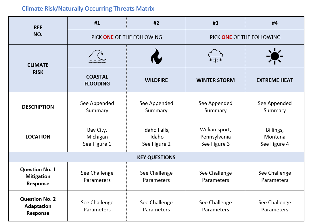
 Location: Bay City / Bay County, Michigan (See Figure 1)
Census Tract: 286000
FEMA Link: https://hazards.fema.gov/nri/coastal-flooding
FEMA defines “Coastal Flooding” as a scenario when water inundates or covers normally dry coastal land as a result of high or rising tides or storm surges.
 The Bay City / Bay County area of Michigan for this assignment is defined as shown within Figure 1 accompanying this problem statement. The problem statement for Scenario #1 is Coastal Flooding. This location is adjacent to the Saginaw Bay / Lake Huron.
The specific location and primary study area to address as part of this problem statement are within Census Tract 286000 as shown within Figure 1 on the following page. The study area consists primarily of the residential areas on both sides of the Kawkawlin River up to the bay. As a result, a portion of the study area is within the adjacent Census Tract of 285900.
Problem Statement – Prepare a Mitigation and Adaptation Response Plan for the primary study area which can be feasibly implemented throughout the community in response to flooding from the Bay. Also consider and present an understanding of how these risks would interact with the Kawkawlin River. Identify one (1) critical element of transportation infrastructure and present a design improvement as part of the plan. The proposed improvement can be mitigation or adaptation response.
- For Example – The proposed Mitigation and Adaptation Response Plan for Scenario #1 may include, but should not be limited to, the following: identifying the critical transportation infrastructure within the primary study area and presenting an understanding how these facilities may be impacted by the naturally occurring threat. The plan may consider the impacts of flooding along the coastline of the bay and banks of the river. The plan may identify mitigation and adaptive design concepts to counteract flooding, manage retreat, and protect settlement areas. The plan may consider how the mitigation and adaptive design concepts will support Community Resilience in advance, during and following flooding events.
Please explain your thought process and justify all your decisions.
Please be sure the transferability and ability of applying the proposed strategies systemically to other communities is considered and presented.
 Scenario #2: Wildfire
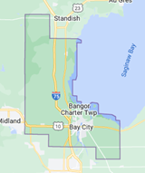
Location: Idaho Falls, Idaho (See Figure 2)
Census Tracts: 971301
FEMA Link: https://hazards.fema.gov/nri/wildfire
FEMA defines “Wildfire” as an unplanned fire burning in natural or wildland areas such as forests, shrub lands, grasslands, or prairies.
The Idaho Falls area of Idaho for this assignment is defined as shown within Figure 2 accompanying this problem statement. The problem statement for Scenario #2 is Wildfire. This location is adjacent to the Snake River and is bounded on all sides by open space/farming land use.
The specific location and primary study area to address as part of this problem statement are within FEMA Census Tract 971301 as shown within Figure 2 on the following page. The study area consists primarily of the residential subdivision west of the Idaho Falls Regional Airport adjacent to tract 971500 and north of Census Tract 971302.
Problem Statement – Prepare a Mitigation and Adaptation Response Plan for the primary study area which can be feasibly implemented throughout the community in response to wildfire risks. Also consider and present an understanding of how the risk would interact with the Idaho Falls Regional Airport and impact the Response Plan. Identify one (1) critical element of transportation infrastructure and present a design improvement as part of the plan. The proposed improvement can be mitigation or adaptation response.
- For Example – The proposed Mitigation and Adaptation Response Plan for Scenario #1 may include, but should not be limited to, the following: identifying the critical transportation infrastructure within the primary study area and presenting an understanding how these facilities may be impacted by the naturally occurring threat. The plan may consider the need for evacuation of residents bounded by the airport and potentially redesign the transportation system which provides protection from wildfire to the airport and other critical infrastructure/facilities. The plan may consider how the mitigation and adaptive design concepts will support Community Resilience in advance, during and following wildfire events.
Please explain your thought process and justify all your decisions.
Please be sure the transferability and ability of applying the proposed strategies systemically to other communities is considered and presented.
 Scenario #3: Winter Storm (Winter Weather)
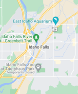
Location: Williamsport, Pennsylvania (See Figure 3)
Census Tracts: 000800, 000600 & 011604
FEMA Link: https://hazards.fema.gov/nri/winter-weather
FEMA defines “Winter Weather” as a scenario consisting of winter storm events in which the main types of precipitation are snow, sleet, or freezing rain.
 The Williamsport area of Pennsylvania for this assignment is defined as shown within Figure 3 accompanying this problem statement. The problem statement for Scenario #3 is Winter Weather. This location is within Central Pennsylvania along the West Branch Susquehanna River.
The specific location and primary study area to address as part of this problem statement are within FEMA Census Tracts: 000800, 000600 & 011604 as shown within Figure 2 on the following page. The primary study area consists of tracts separated by the West Branch Susquehanna River; but also include a university, a mixed use of residential/commercial land uses, and a local transit service system.
Problem Statement – Prepare a Mitigation and Adaptation Response Plan for the primary study area which can be feasibly implemented throughout the community in response to Winter Weather. The plan requires the Community identify three (3) feasible locations for community warming centers which will be accessible in advance, during and following Winter Weather events. Identify one (1) critical element of transportation infrastructure and present a design improvement as part of the plan to respond to the winter weather scenario. The proposed improvement can be mitigation or adaptation response.
- For Example – The proposed Mitigation and Adaptation Response Plan for Scenario #1 may include, but should not be limited to, the following: identifying the critical transportation infrastructure within the primary study area and how these facilities may be impacted by the Winter Weather threat. The plan shall include locations for three (3) community warming centers; but may also consider the impacts of winter storms along the primary corridors of the town and the ability of residents to maintain accessibility to critical infrastructure and the proposed warming centers. Identify one (1) critical element of transportation infrastructure and present a design improvement as part of the plan to respond to the Winter Weather. The proposed improvement to critical infrastructure can be mitigation or adaptation response. The plan should implement mitigation and adaptive design concepts to support Community Resilience in advance, during and following Winter Weather events.
Please explain your thought process and justify all your decisions.
Please be sure the transferability and ability of applying the proposed strategies systemically to other communities is considered and presented.
 Scenario #4: Extreme Heat (Heat Wave)
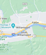
Location: Billings, Montana (See Figure 4)
Census Tracts: 000401 & 000402.
FEMA Link: https://hazards.fema.gov/nri/heat-wave
FEMA defines a “Heat Wave” as a period of abnormally and uncomfortably hot and unusually humid weather typically lasting two or more days with temperatures outside the historical averages for a given area.
__________________________________________________________________________________

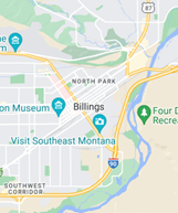
The Billings, Montana area for this assignment is defined as shown within Figure 4 accompanying this problem statement. The problem statement for Scenario #4 is Heat Wave. Billings is a city in southern Montana on the Yellowstone River.
The specific location and primary study area to address as part of this problem statement are within FEMA Census Tracts: 000401 & 000402. These areas are located south of the Billings Logan International Airport and are bounded by tracts with a “Relatively High: risk of Heat Wave risk. The City Limits of Billings extend beyond the identified tracts, but the defined tracts are high-density residential and include Billings Hospital and Billins Senior High School.
Problem Statement – Prepare a Mitigation and Adaptation Response Plan for these tracts which can be feasibility implemented within the defined tracts of Billings, Montana in response to Extreme Heat / Heat Wave. The plan requires the Community identify three (3) feasible locations for community cooling centers which will be accessible in advance, during and following Extreme Heat events. Identify one (1) critical element of transportation infrastructure and present a design improvement as part of the plan to respond to the extreme hear scenario. The proposed improvement to critical infrastructure can be mitigation or adaptation response.
- For Example – The proposed Mitigation and Adaptation Response Plan for Scenario #1 may include, but should not be limited to, the following: identifying the critical transportation infrastructure within the primary study area and how these facilities may be impacted by the Extreme Heat. The plan shall include locations for three (3) community cooling centers; but may also consider the impacts of extreme heat to residents and their accessibility to critical infrastructure. Identify one (1) critical element of transportation infrastructure and present a design improvement as part of the plan to respond to the Extreme Heat. The proposed improvement to critical infrastructure can be mitigation or adaptation response. The plan should implement mitigation and adaptive design concepts to support Community Resilience in advance, during and following Extreme Heat.
Please explain your thought process and justify all your decisions
Please be sure the transferability and ability of applying the proposed strategies systemically to other communities is considered and presented.
For questions, contact Kathi Driggs.