Community Planning Month
October is Community Planning Month hosted by the American Planning Assocation. Planning is more important than ever as communities continue to navigate the disruptive changes brought about by the pandemic. From economic development and transportation planning to reinventing what our communities look like post-COVID-19, this October share how planning and planners are leading the way forward for all in your community.
2023

Safe Routes to School (SRTS) Master Plan REFRESH, City of Lancaster, CA, USA
Lancaster School District; Lancaster School District; Eastside Union School District; Westside Union School District; Antelope Valley Union High School District; Sacred Heart School; Desert Christian School; Antelope Valley Hospital; Antelope Valley Partners for Health; Antelope Valley Schools Transportation Agency; Antelope Valley Transit Authority; Antelope Valley YMCA; Kaiser Permanente; Lancaster Sunrise Rotary Club; Los Angeles County Sheriff’s Department; and Team Lakays Cycling Club
The goal of this project was to update the City’s SRTS Master Plan to account for the significant changes to the built environment, school attendance zones, the economy, local work and travel patterns, and demographics that have occurred since the development of its original plan (2013).
This project was undertaken during the national shutdown prompted by the spread of COVID-19. However, the City did not want to postpone the much-needed update that it would need to support the City’s application to Cycle 6 of the Active Transportation program. Therefore, all elements of the community engagement that was done to support this update were accomplished virtually, including the walk audits which utilized PublicCordinate (an interactive map-based platform where public agencies and developers can share project information with the public to gather feedback. Users can customize it to their own projects, translate it into multiple languages, upload project photos to the map, and export fully formatted reports with summary analytics.).

City of Parsons’ Connected RRFB Boosts Safety and Efficiency, City of Parsons, KS USA
City of Parsons, KS
This past July, the City of Parsons, KS installed a new pedestrian-activated warning device at a well-used crosswalk linking two sides of the community.
The system, manufactured by Carmanah Technologies, is the first of its kind to be installed anywhere in the world. Although it resembles the rectangular rapid flashing beacons (RRFBs), now ubiquitous at midblock crosswalks, Parson’s RRFB has one key differentiator: built-in remote connectivity.
That means that in addition to increasing crosswalk visibility, yield rates, and pedestrian safety, the device allows city personnel to manage their assets remotely, including monitoring battery health, changing settings, and enabling alerts that ensure optimal uptime and safety.
Having the RRFBs ‘online’ also means the City will be able to gain insight into their utilization. Staff can log into the cloud software to view and download usage data like daily activation counts that can be used to demonstrate engagement and inform future investments.

Innovate Mound, Macomb County, MI, USA
Macomb County Department of Roads, HNTB, Dan’s Excavating Inc., and Ajax Paving
The Innovate Mound project is a significant investment to rebuild a major manufacturing corridor to create safe, modern, efficient, and reliable infrastructure to retain jobs today and sustain future economic growth in Macomb County. Mound Road is a roadway that connects people, communities, and commerce. It is one of the most densely packed manufacturing regions in the U.S. and supports more than 200,000 jobs in Macomb County and across the state.
Innovate Mound will strengthen the region and enhance connectivity by incorporating state-of-the-art design and smart technology to create a modern corridor. The Mound Road corridor is a showcase for the future of transportation safety and mobility, implementing a diverse degree of data-smart traffic management strategies, connected and automated vehicle (CAV) technologies, advanced software, automation, and scientific techniques, leveraging new regional partnerships to deliver a system that is innovative and can be extended across the county, region, and neighboring states.
The key to innovation on Mound Road is the development of a solid infrastructure and communications foundation. A hybrid (wireline/wireless) communications network is being constructed for MCDR’s signals and intelligent transportation system (ITS) infrastructure to the Communications & Technology Center (COMTEC), consisting of robust fiber optic communications and licensed wireless backhaul radios. The project is adding new capabilities that are layered on top of the infrastructure foundation to create a corridor which is forward flexible to the evolving transportation technological landscape, allowing Mound Road to be used as a test bed and validation corridor for new mobility services.

Saundersville Road Roundabout Project, City of Hendersonville, TN, US
City of Hendersonville; Al-Neyer Commercial Real Estate Development; Kimley-Horn
The project is the result of collaboration between the City of Hendersonville and the Al-Neyer Commercial Real Estate Development to mitigate intersection impacts from a 250-unit, multi-family residential development. The roundabout enhances pedestrian and vehicular safety and operation at the intersection of Saundersville Road, a commercial access road, and Indian Lake Boulevard. This commercial access road serves as the primary ingress/egress for the proposed development, an existing multi-family residential complex, restaurants, boutiques, and big-box stores.
Prior to completion of the project, 42 crashes were recorded at the intersection in the previous five years, traffic frequently queued from the traffic signal to commercial access road, and pedestrians crossed four lanes of traffic to traverse the intersection. The newly completed Saundersville Roundabout Project facilitates controlled, continuous flow of traffic from all directions through the intersection, increased the capacity of the traffic signal by adding a left-turn lane, optimized signal timing, and improved pedestrian travel by reducing crossing lengths and providing refuges at splitter islands.

Rio Grande Avenue Pedestrian Safety Study, Orlando, FL US
Public Works Department, Orange County, Florida; VHB Inc.; Humberto Castillero, P.E., PTOE; Dr. Masood Mirza, P.E., PTOE, (F), Lauren???? Torres, RSP1, Vibhuti Patel, P.E., Cristina Cruz
Project Overview
- A proactive approach to address neighborhood pedestrian and bicycle safety.
- Develop alternative strategies to address the mobility needs of all users along the corridor.
- Provide for safer integration of pedestrians and bicyclists with other modes of transportation, utilizing a context-sensitive approach.
- Enhance non-vehicular commute options.
- Implement “Walk-Ride-Thrive!” and “INVEST in Our Home for Life” initiatives.
- Enhance neighborhood beautification and safety.
- Bring neighbors closer and increase home values.
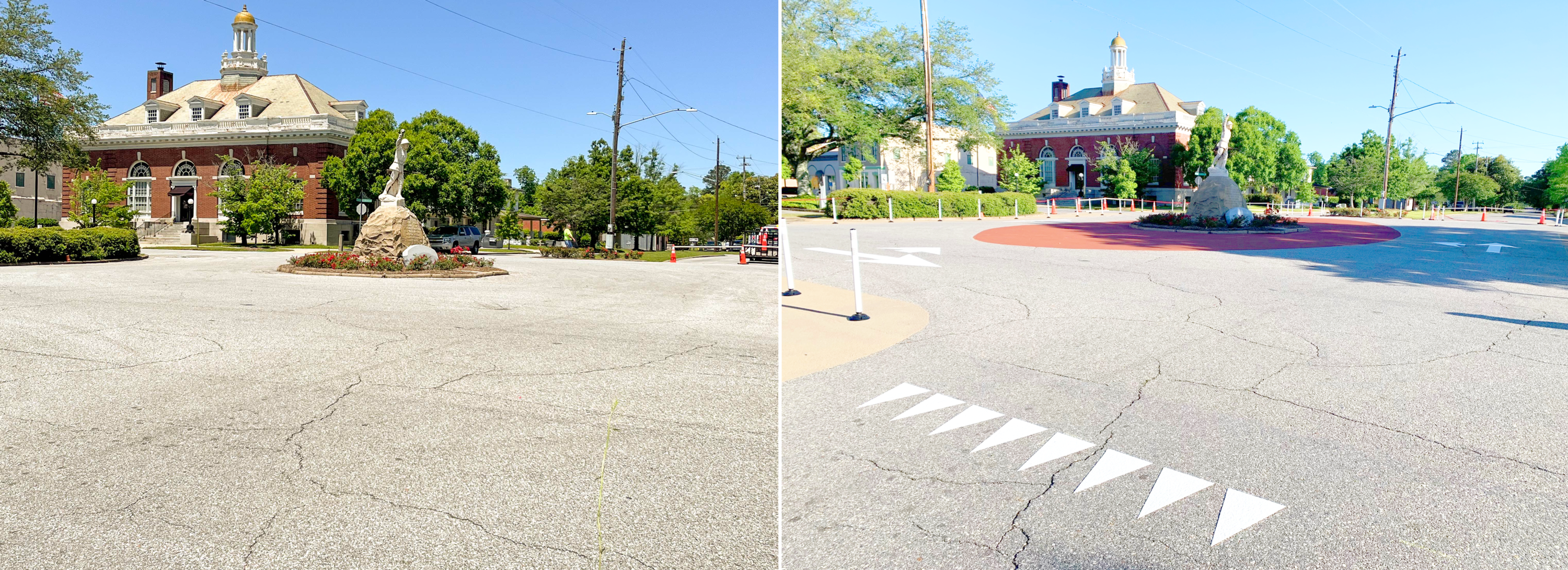
Community-Installed Roundabout, Eufaula, AL, US
Eufaula City Council, Main Street Eufaula, Barbour County Extension, Alabama Extension at Auburn University, Auburn University Civil Engineers, City of Eufaula Public Works Department, Youth Leadership Barbour County, Alta Planning
Eufaula, AL’s Historic Downtown is a vibrant hub of activity for the small community, where residents and out-of-town visitors shop, eat, visit trails, and play in the parks. However, the downtown intersections have awkwardly placed statues in the center, causing crashes, unsafe turning movements, and right-of-way confusion for pedestrians, cyclists, and motorists. In response, the interagency team worked to write an active transportation action plan for their community, which included a retrofitted roundabout design to make one of the main intersections safer for all users and improve the livability of the downtown area. Based on this plan, interagency team members personally painted a new roundabout circle, arrows, and crosswalk markings as well as installed bollards, planters and signs. All users now move seamlessly through the roundabout, with unsafe movements reduced by over 35% and bicycle ridership increased over 100%.
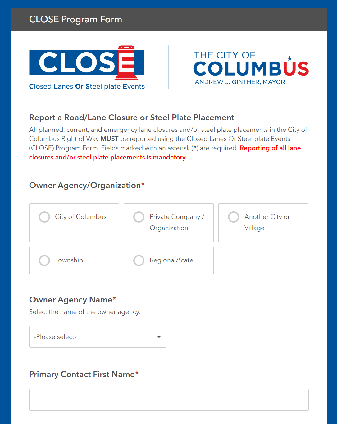
CLOSE Program (Closed Lanes Or Steel-plate Events), Columbus, OH US
Department of Public Service (DPS) Data Solutions & Compliance Group. Leads: Russ Bowerman and Kim Baillieul
The goal of the project is to establish a single, authoritative, active database for tracking closures within the Right of Way accompanied with user-friendly tools; promote participation and compliance with the program.
CLOSE has allowed for project planning, conflict detection, and safety analysis – with 261 roadway closures and 3,077 plates captured YTD. Having readily available 24-hour emergency contact information for all plates, especially during off-hours, has already proven beneficial; last December, a plate was knocked out of place around 3am, but staff were able to identify the plate owner and remedy the situation within minutes.

South Van Ness Quick-Build Project, San Francisco, CA, US
San Francisco Municipal Transportation Agency (SFMTA)
South Van Ness Avenue is on San Francisco’s High Injury Network, the 12% of city streets that account for over 68% of serious injuries and fatalities. The goal of the South Van Ness Quick-Build Project is to implement safety improvements to increase visibility, safety, and access to those who walk, bike, and drive on the corridor.
Project elements include: Road diet (reduced from four travel lanes to three with a center turn lane); Left turn pockets installed at intersections; Signal timing changes on South Van Ness Avenue between 14th Street and Cesar Chavez.

Ringling Trail Complete Streets, City of Sarasota, FL, US
The City of Sarasota, in collaboration with regional partners and stakeholders, has been at the forefront of advocating for enhanced multimodal transportation options. The Legacy Trail Extension, overwhelmingly approved by Sarasota County voters in 2018, serves as a pivotal catalyst for this initiative. The extension adds an additional 7 miles to the existing 11-mile corridor, thereby connecting Venice to downtown Sarasota. This extension is not merely a recreational path; it hosts over 500,000 trips annually, serving as a vital artery for commuters and recreational users alike.
The Florida Department of Transportation's SUNTRAIL plan further amplifies this need. The Gulf Coast Regional Trail, part of the SUNTRAIL, proposes a comprehensive loop through Sarasota and Manatee Counties, intersecting at downtown Sarasota. This necessitates a safe, efficient, and well-marked conduit for bicyclists transitioning from the Legacy Trail Extension to the barrier islands and beyond.
In 2019, the City Commission approved the Multi-Modal Connections Plan, which specifically identified Ringling Blvd as a potential complete street project. Public outreach was conducted in 2020, and the feedback was overwhelmingly in favor of protected bicycle lanes augmented with landscaping features. The City Commission subsequently approved the Basis of Design Report and Concept Plan in February 2021, with the dual aim of encouraging bicycling and stimulating economic activity in the downtown area.
2022

The Redesign of Saint-Jean Street, Roberval, QC, Canada
Individuals Involved: Jean-Luc Gagnon, Roberval City Engineer, Paul Mackey, MITE, Safestreet Inc., Guillaume Carrier, engineer at Tetra-Tech.
The project was designed in 2020, built in 2021 and was named Project of the Year by the Quebec Association of Municipal Engineers in Sept. 2022
The City of Roberval wanted to improve the living conditions along the street in a low-income area of the town. As part of the redesign, rather than narrowing the road on both sides, the road was shifted to create a green space in front of a row of townhouses owned by the Municipal Housing Authority. Residents have been pleased to have a small space where their children can play under supervision in front of their home.
The impermeable surface has been reduced there and elsewhere on the street (with planting strips), saving money on overflow features, and trees have been planted, reducing runoff and heat-island effects. Residents have adopted the new vegetation, taking care of the bushes and trees planted on City property. The planting strips and trees have greatly improved the aesthetics of the area. The project has also improved traffic safety and speed, to the residents’ satisfaction.

Renovation of BYU College of Fine Arts and Communications, Provo, UT
Names of Organizations: Provo City, Utah Department of Transportation (UDOT) , and Brigham Young University (BYU)
Individuals Involved: Kaehan Shour (Transportation Engineer), Rob Hunter (Assistant City Engineer), Tim McCloud ( Traffic Electronic Specialist), and Preston Deuel ( Engineering Technician) all from Provo City
BYU’s college of fine arts and communications is going through a renovation. BYU decided to use Provo High School as a temporarily house for the college of fine arts and communications.
This change is making roughly 800 students to cross a high volume, high speed, main arterial road on daily basis. Provo City toke below short term measures to provide students with a safer crossing:
- Closed the second free flow lane to shorten walking distance.
- Installed proper signage to raise awareness.
- Installed two PHB’s with Pedestrian crossing buttons.
- Installed temporary rubber curbing to close the second free flow lane.
- Installed traffic delineators to raise awareness.
- Updated Striping.
Provo City has also taken below measures as a long term solution to provide students with a safer crossing:
- Applied for Safe Streets for All (SS4A) grant.

SEE AND BE SEEN Active Transportation Safety Campaign, City of Lancaster, CA, U.S.
The City of Lancaster’s SEE AND BE SEEN active transportation safety campaign works to educate residents on being safe drivers, bicyclists, and pedestrians.

Improving Pedestrian and Bike Access and Safety near University of Florida, City of Gainesville, FL, U.S.
Name of Agencies: City of Gainesville, University of Florida, Florida Department of Transportation
Individuals: Jesus Gomez, Director of Department of Transportation, City of Gainesville; Deborah Leistner, Transportation & Parking Manager, City of Gainesville; Emmanuel Posadas, Traffic Operations Manager, City of Gainesville; Scott Wright, Planner, City of Gainesville; Subhadipto Poddar, Engineer and Utility Designer, City of Gainesville; Robert Schenck, ITS, CV, and AV Program Manager, City of Gainesville
A challenging task in a university town is maneuvering multimodal transportation safely in and around campus without jeopardizing overall mobility along major corridors. In Gainesville, W University Avenue, a major constrained corridor that carries over 20,000 vpd abuts UF campus. Over a 3 year period (2016-2018) 150 crashes occurred at 4 intersections accessing campus, of which 79 resulted in severe injuries and 1 death; up to 864 pedestrians cross each of these intersections daily during midday peak times. The Gainesville Transportation Department in collaboration with UF and FDOT converted the 4 corridors along University Ave into one-way pairs with protected bike facilities, bike signals, and leading pedestrian intervals; the project also removed turn movements along University Ave reducing the number of conflicts between the different modes as part of the City’s Vision Zero strategy. The safety effort continues with the application of video detection and research into predictive crash analysis.

Improving Pedestrian Safety, City of Cornelius, OR, U.S.
Organizations: ODOT, City of Cornelius, Centro Cultural, and Virginia Garcia Clinic
The Oregon Department of Transportation and City of Cornelius leaders took a major step toward making a safer community for everyone Friday by inaugurating a new rectangular rapid flashing beacon that speaks both Spanish and English to pedestrians on Tualatin Valley Highway. The new beacon will serve the growing multi-cultural Cornelius community and improve safety along the busy highway. The RRFBs have become an increasingly familiar sight on state and local roads. They improve safety by allowing pedestrians to activate flashing amber lights that alert oncoming motorists to people preparing to cross the road. ODOT started using pedestrian activated beacons on Portland area roads a decade ago and has found them an effective tool for improving safety on busy corridors, especially in areas with long distances between traffic signals. The new Cornelius beacon is part of a continuing effort by ODOT, the City, Centro Cultural and Virginia Garcia Clinic to improve safety and integrate equity into design and construction of projects.

Downtown Streets Circulation Project, City of Redding, CA, U.S.
Individuals Involved: Chuck Aukland, P.E., Public Works Director, City of Redding, CA; James Triantafyllou, P.E., Assistant Public Works Director, City of Redding, CA; Steve Bade, Deputy City Manager, City of Redding, CA; Russell Wenham, P.E., PTOE, Project Manager, GHD Inc., Redding, CA; Meghan Sigler, P.E., Project Engineer, GHD Inc., Redding, CA; Jeff Bline, P.E., Construction Manager, GHD Inc. Redding, CA; Ryan Russell, Project Architect, RAD Studio, Redding, CA; Eric Stephens, Chief Operating Officer, SNL Group Inc., Redding, CA; Dan Imlach, Project Superintendent, SNL Group Inc., Redding, CA; Allen Knott, CEO, K2 Development Company, Redding, CA; Daniel Knott, Executive Officer, K2 Development Company, Redding, CA
The City of Redding Downtown Streets Circulation Project is a local road transportation project that is the centerpiece of downtown transformation and revitalization in Redding, California. This project used an Affordable Housing and Sustainable Communities grant from the State of California to reintroduce a downtown streets that had been closed to vehicular traffic since 1972. The project reconnects business and residential uses – providing equitable access for hundreds of new multi-family residences.
The Streets Project was the culmination of several years of planning that included a new Downtown Transportation Plan and a new Downtown Specific Plan. Extensive community and stakeholder outreach resulted in community-supported plans for revitalization.
One key achievement from the Streets Project has been the rebound of Market Street after reopening to pedestrians, bicycles and vehicle traffic. Vibrancy has returned to downtown Redding and it is common to see bicyclists and pedestrians of all ages using the new connections.
2021

Pedestrian-Only Plaza, City of Alexandria, VA U.S.
One of the City's most successful placemaking and COVID-19 recovery initiatives during the pandemic has been the conversion of the 100-block of King Street into a pedestrian-only plaza. This plaza is the first of its kind in Alexandria, features in-street dining options, and has been incredibly popular with residents. A recent survy of 2,700 residents found that 89 percent of respondents had a positive experience with the pedestrian zone, and a strong majoirity of residents and businesss want to see the program continue.
Additionally, the City is planning to launch a Neighborhood Slow Zone pilot initiative, which will provide traffic calming and gateway treatments for neighborhoods experiencing challenges with vehicle volumes and speeds. The initiative is part of the City’s broader Vision Zero effort to eliminate fatal and severe injury crashes.
Adaptive Roadways Program, City of Calgary, AB Canada
Agencies and Organizations Involved: City of Calgary staff including Ravi Seera, Anthony El-araj, Patrick Grisak, Brian Lee, Tara Norton-Merrin, Kennith Lin, Fiona Wyllie, Robin Stanton, and Andrew Sedor.
To help provide Calgarians with the space needed to social distance and be able to walk, run, skateboard and cycle, The City of Calgary has implemented an Adaptive Roadways Program (ARP) in 2020. Under the program, road lanes are closed to motor vehicle traffic so they can be used by people who are walking, running, cycling, and rollerblading.
Over the course of the program, 14 km of adaptive roadways were installed at 20 unique locations. Calgary currently has 12 km of Cycle Track. thus, the Adaptive Roadway program has doubled the amount of separated on street active modes space in Calgary in 2020 and 2021.
With restrictions easing, and traffic flow returning to normal levels, The City analyzed what adaptive roadways had high use and are sustainable long term. Then, installed permanent infrastructure at four locations. This has added 3 km of new active modes infrastructure to the transportation network.

West 17 Avenue and 37 Street S.W. Main Streets, City of Calgary, AB Canada
Agencies and individuals involved: City of Calgary staff including Syed Atif Ali, Natalie Coombes, Michael Magnan, Ryan Mortson, ISL Engineering and Land Services Ltd., IBI Group, Alsa Road Construction
The goals of The City of Calgary’s Main Streets Program are to attract growth and investment in communities by using community planning best practices to redesign both popular and emerging streets that are cultural, social and economic focal points in the city. Main Streets are resilient, adaptable and attractive places that celebrate community character and create sustainable and vibrant communities that encourage diversity.
With that in mind, The City of Calgary is in the process of transforming West 17 Avenue S.W. and 37 Street S.W. into areas where people want to live, work and play through re-development and significant infrastructure upgrades.
Using the Main Streets Master Plan, the project team is enhancing pedestrian safety and comfort, improving mobility options, increasing green amenities, providing additional street furniture, improving connections to parks and amenities throughout the community, and advancing community destinations that will support local businesses.
By undertaking construction with a coordinated approach, The City of Calgary is renewing ageing infrastructure and transforming these streets to have a positive impact on the communities and citizens in the area.

Range Line Road Description, City of Carmel, IN, U.S.
American Structurepoint served as the program manager/designer for the Range Line Road corridor for the City of Carmel, supported by a variety of industry consultants designing particular segments and roundabout intersections.
The City of Carmel transformed Range Line Road from a 5-lane roadway to a pedestrian-friendly, tree-lined, multimodal roundabout corridor with protected bicycle and pedestrian pathways. A landscaped center median along the corridor eliminates left-hand turns. The corridor’s multimodal transportation options were designed to provide higher priority to pedestrian and bicycle traffic by implementing wide multi-use paths, a street-level separated cycle track, and raised crosswalks at roundabout intersections and key midblock crossing locations.
The raised crosswalks increase safety for pedestrians by physically reducing the speeds of vehicles at major pedestrian crossing areas. Higher priority for pedestrians and bicycles promotes walkability and bikeability, which contributes to an active, healthy lifestyle providing residents with reasonable alternatives to driving.
Streeteries Program, City of Stamford, CT, U.S.
Agencies and Individuals Involved: City of Stamford Transportation, Traffic & Parking Department and Stamford Downtown Special Services District
Frank Petise and Luke Buttenwieser (Traffic and Parking). David Kooris, Lynne Colatrella, and Michael Moore (Stamford Downtown)
Like many places, Stamford’s restaurant industry faced significant challenges with the on-set of COVID-19 and the associated lockdowns. In response, the City of Stamford and the Stamford Downtown Special Services District (DSSD) quickly launched the Streateries program offering extended outdoor dining on the streets and sidewalks in Downtown Stamford. In 2020, this project transformed over 130 parking spaces into places for people to dine and undoubtedly saved Stamford’s restaurants. In 2021, this project was continued and upgraded to offer improved seating options and added landscaping. The City and DSSD began to look at approaches to further cement this program by permanently widening sidewalks and eliminating parking. The Transportation Department is currently in design to rebuild Summer Street to eliminate parking and widen the sidewalks by 8’ on either side to transform the outdoor dining landscape. This project shows how Stamford responded to COVID, adapted, and is planning for the future.

Pedestrian Master Plan, City of Costa Mesa, CA, U.S.
Agencies and Organizations Involved: City of Costa Mesa and KOA Corporation
City of Costa Mesa, California was able to collect community input during the pandemic for its citywide Pedestrian Master Plan. A series of walk audits at six locations were conducted both in-person and virtually in early 2021. Community members had the option of joining a traditional in-person walk audit or participating virtually. The socially distanced in-person walk audits, led by City staff and KOA consultant team, had 81 attendees.
Other attendees could participate on the same walk audit tour routes or additional routes on their own time using an on-line interactive tool. A total of 484 comments associated with walk audits were collected through on-line GIS tools, in-person meetings, and other social media. These comments were considered during development of the policies and recommendations for the Pedestrian Master Plan. Public engagement for this project was spotlighted by the news media, including the Los Angeles Times.
Shared Streets and Mobility Lane, Edmonton, AB, Canada
Shared Streets and Mobility Lanes are one way we can help everyone stay safe and comply with Alberta Health Services physical distancing guidelines. This work was initiated in Spring 2020, as we adapted to the COVID pandemic. Shared Streets are open for people to use to bike, walk, or other active modes. Since all modes are using the same space with a Shared Street, the speed limit is reduced to 20 km/h.
Mobility Lanes open the use of a vehicle lane for people to use for physical activity by closing the lane to vehicle traffic and reducing speed limit to 40 km/h. The locations for 2021 were selected based on population density, pedestrian activity, type and design of the road, safety as well as feedback and data from the 2020 implementation. These temporary installations will be maintained until late Fall 2021.

Turk Play Streets and Safe Passage Park, San Francisco, CA, U.S.
COVID-19 disproportionately impacted people in the Tenderloin neighborhood, which is home to San Francisco’s most underserved communities. In collaboration with the Tenderloin Community Benefit District and Livable City, the San Francisco Municipal Transportation Agency’s Play Streets program created space for families and children to play. Play Streets partners with community organizations in the most underserved neighborhoods in terms of open space and recreational opportunities, which also correlates closely with San Francisco’s largest minority communities.
In fall 2020, a weekly closure of Turk Street between Leavenworth and Jones streets provided temporary, car-free open space for children, seniors, and neighbors to enjoy every Saturday. Play Streets created places for children to play, areas for COVID-19 testing, and recreational space for neighbors. In spring 2021, the Turk Play Streets evolved into Safe Passage Park, a block-long parklet and activation space that offers community programming and collaboration.
Greenwich Avenue & Elm Street Intersection Improvement, Town of Greenwich, CT, U.S.
The Greenwich Avenue and Elm Street Intersection Improvement Project exemplifies how strategic planning can make a community more equitable and resilient during the COVID-19 pandemic. Traffic on Greenwich Avenue – the Town’s shopping and dining destination – increased during pandemic due to the public working from home and not traveling. To ensure Greenwich Avenue remains a safe and desirable place for the public, Department of Public works implemented slow streets design to the Greenwich Avenue and Elm Street intersection. Curb extensions were installed to reduce the crossing time and distance for pedestrians by up to 40 percent and sidewalks were widened into the paved roadway to slow down motorists. The roadway was raised to improve visibility between pedestrians and motorists, and the speed of vehicles. To enhance the streetscape’s appearance, green-space increased from 340 square feet to 1,860 square feet. Future projects on Greenwich Avenue include designated areas for outdoor dining.