Pedestrian Safety Showcase
October is Pedestrian Safety Month! Below are projects from ITE Public Agency members that demonstrate the increased emphasis on pedestrian safety.
This will be an ongoing resource that will showcase current and previous projects.
2024 Projects
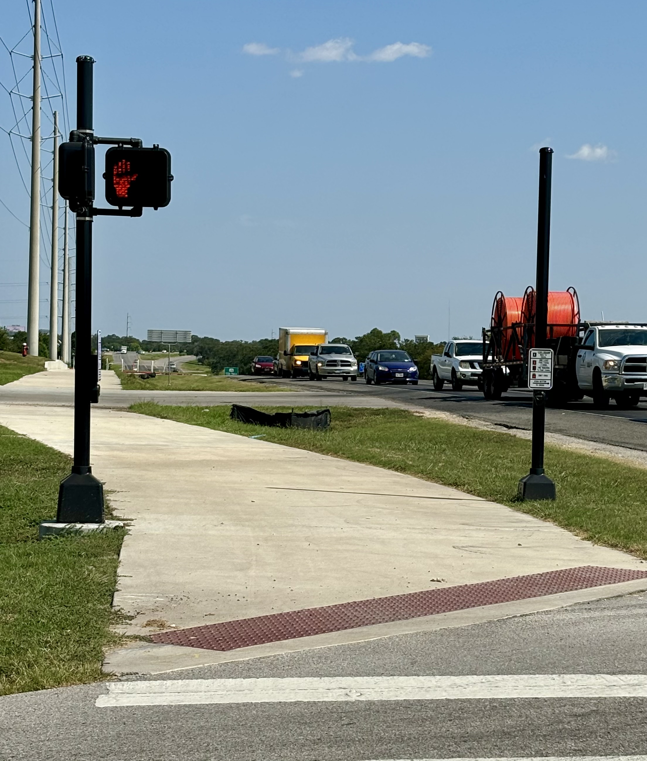
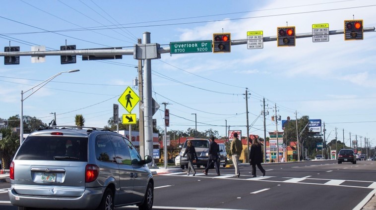
FM 2818 (Harvey Mitchell Parkway)
Texas Department of Transportation (TxDOT) Bryan District (BRY), Bryan, TX, USA
Jeff Miles, P.E., District Design Engineer, TxDOT Bryan District; Mark Poage, P.E., Transportation Engineer, TxDOT Bryan District; and Ashley Hill, P.E., Director of Transportation Operations, TxDOT Bryan District
FM 2818 is a critical arterial road linking Bryan and College Station, serving as a primary route to Texas A&M University (TAMU), the TAMU RELLIS Campus, Easterwood Airport, and key industrial parks. With rising student populations at TAMU and Blinn College, traffic congestion has increased substantially, raising pedestrian safety and traffic flow concerns.
To address these issues, the Texas Department of Transportation Bryan District (TxDOT BRY) prioritized the safety of pedestrians and cyclists. As part of the Highway Safety Improvement Program (HSIP), a new multi-use path (MUP) was constructed along the corridor near an intermediate school. This pathway connects the school directly to FM 2818, allowing students, parents, and community members to walk or bike safely to and from the school. Enhanced safety features include curb walls, pedestrian rails, and a designated pedestrian crossing.
This project highlights TxDOT’s dedication to safety (#EndTheStreakTX) while enhancing accessibility and supporting long-term community development.
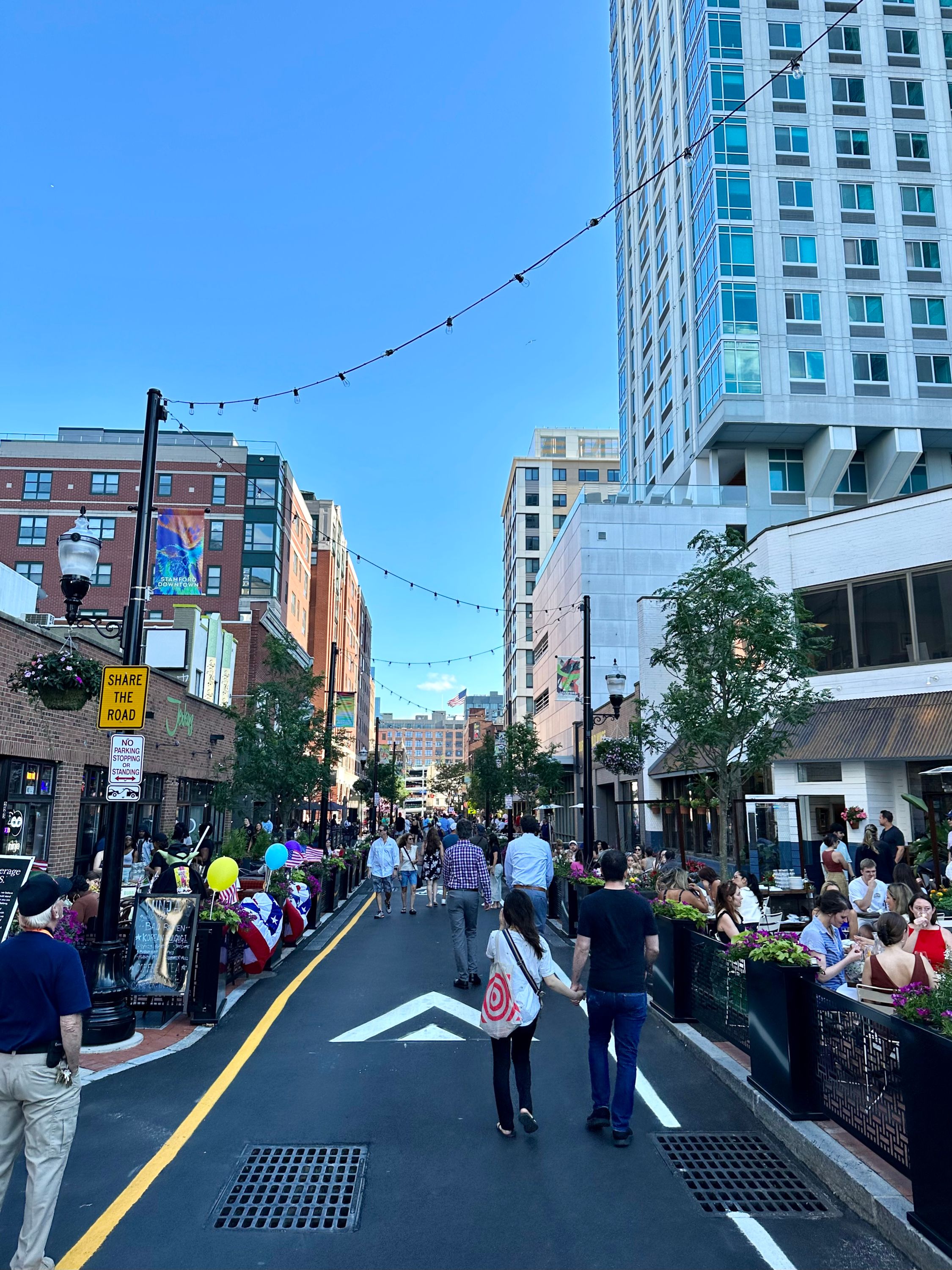
Lower Summer Street Pedestrian Promenade
City of Stamford Transportation, Traffic & Parking Department, Stamford, CT, U.S.
Luke Buttenwieser, Transportation Planner, City of Stamford Transportation, Traffic & Parking Department; Frank W. Petise, P.E., Bureau Chief, City of Stamford Transportation, Traffic & Parking Department; John Guzze, P.E., Associate, Fuss and O'Neill
This project transformed Lower Summer Street in Downtown Stamford from a car-centric roadway to a people-centric one. The parking was eliminated and sidewalks on both sides of the road were widened by 8-10 feet (2.4-3 meters) to support outdoor dining. Additionally, the entire roadway was raised to support festival street closures.
New street trees, bioswales, and roadway lighting creates a sustainable sense of place. With this project, a new Downtown hub was created with space for more than 300 outdoor dining seats, ADA compliant sidewalks, and a true sense of place.
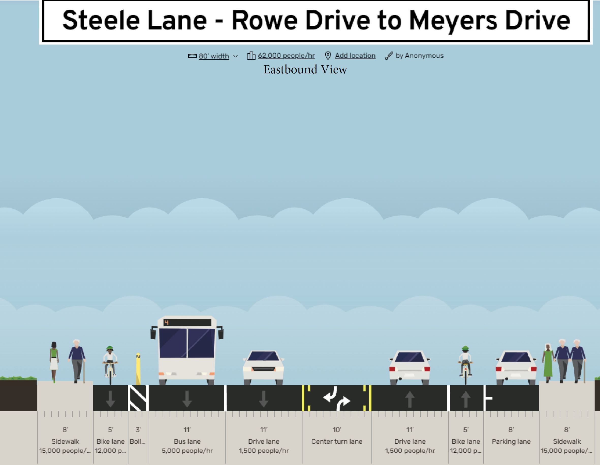
Steele Lane Pilot Project
City of Santa Rosa, CA, Santa Rosa, CA, USA
Rob Sprinkle, P.E., T.E., City Traffic Engineer, City of Santa Rosa; Mike VanMidde, T.E., Associate Traffic Engineer, City of Santa Rosa; Torina Wilson, Transportation Planner, City of Santa Rosa; Alexander Oceguera, Active Transportation Planner, City of Santa Rosa, CA
The City of Santa Rosa conducted its first school safety pilot project in Spring 2024 in front of Steele Lane Elementary School. A Safe Routes to School proposal, the pilot allowed City staff to review how bus, bicycle, and pedestrian space in front of the school may be more appropriately used. Steele Lane is a significant vehicle thoroughfare and is one-quarter mile from a Highway 101 interchange.
The pilot project removed a westbound travel lane and re-assigned it as a drop-off/pick-up zone. Initial observations included a four percent (1.6 miles per hour [mph]) (2.6 kilometers per hour [km/hr]) decrease in speeds outside of school drop-off/pick-up and a fourteen percent (5.4 mph) (8.7 km/hr) decrease in speeds during school drop-off/pick-up. Additionally, traffic signal timing was refined to reduce queues and support increased pedestrian crossings. Video recordings showed potential near miss collisions that were avoided with the installation.
Following the initial pilot, "Phase 2" removes an eastbound travel lane, adds a two-way left turn lane, adds a protected westbound bike lane, and creates a permanent loading zone, further separating students from moving traffic. Should Phase 2 be as successful, it will remain as the permanent installation and/or be tweaked to fine tune additional elements.
2023 Projects

Coal Mine Avenue Crosswalk Improvement, Golden, CO, US
Jefferson County Transportation & Engineering Division (Kelly Dunne, P.E., PTOE, Traffic Operations & Planning Manager and Christina Lane, AICP, Senior Transportation Planner)
The Coal Mine Avenue Crosswalk Improvement serves to enhance pedestrian safety at the intersection of Coal Mine Avenue and Van Gordon Way in unincorporated Jefferson County, Colorado. With proximity to several K-12 schools and a regional park, pedestrian safety became a concern with students and nearby residents crossing Coal Mine Avenue consistently throughout the day. In its original configuration, the intersection lacked crosswalk enhancements and pedestrians were required to cross seven lanes of traffic.
A preferred design was selected after analyzing traffic data, reviewing pedestrian activity, and conducting public engagement. This design included Rectangular Rapid Flashing Beacons (RRFBs) as well as pedestrian islands and bump outs that reduced the number of lanes pedestrians must cross. Along with new striping, signage, and ADA-compliant directional ramps, the enhancements alert drivers to pedestrian activity and create a safer and more comfortable experience for those walking and wheeling across Coal Mine Avenue.

Safe Routes to School (SRTS) Master Plan REFRESH, City of Lancaster, CA, USA
Lancaster School District; Lancaster School District; Eastside Union School District; Westside Union School District; Antelope Valley Union High School District; Sacred Heart School; Desert Christian School; Antelope Valley Hospital; Antelope Valley Partners for Health; Antelope Valley Schools Transportation Agency; Antelope Valley Transit Authority; Antelope Valley YMCA; Kaiser Permanente; Lancaster Sunrise Rotary Club; Los Angeles County Sheriff’s Department; and Team Lakays Cycling Club
The goal of this project was to update the City’s SRTS Master Plan to account for the significant changes to the built environment, school attendance zones, the economy, local work and travel patterns, and demographics that have occurred since the development of its original plan (2013).
This project was undertaken during the national shutdown prompted by the spread of COVID-19. However, the City did not want to postpone the much-needed update that it would need to support the City’s application to Cycle 6 of the Active Transportation program. Therefore, all elements of the community engagement that was done to support this update were accomplished virtually, including the walk audits which utilized PublicCordinate (an interactive map-based platform where public agencies and developers can share project information with the public to gather feedback. Users can customize it to their own projects, translate it into multiple languages, upload project photos to the map, and export fully formatted reports with summary analytics.).
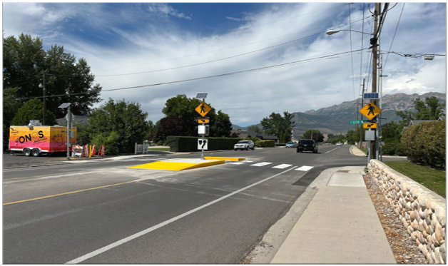
3230 N Canyon Road Pedestrian Crossing, Provo, UT US
Provo City (Chris Kent, David Christensen, David Michelsen, Kade Hubbs, Kaehan Shour, Preston Deuel, Tim McCloud, and Vern Keeslar)
The goal of this project was to make this high volume, high speed, local arterial road a safer crossing for pedestrians and vehicles. The key accomplishments included the installation of three RRFB's, push buttons on each pole, detectable warning surfaces at each side of the road, ADA ramps, a refuge island in the middle of the road, high yield crosswalk bars, and advance warning crosswalk signs for each direction.

City of Parsons’ Connected RRFB Boosts Safety and Efficiency, City of Parsons, KS USA
City of Parsons, KS
This past July, the City of Parsons, KS installed a new pedestrian-activated warning device at a well-used crosswalk linking two sides of the community.
The system, manufactured by Carmanah Technologies, is the first of its kind to be installed anywhere in the world. Although it resembles the rectangular rapid flashing beacons (RRFBs), now ubiquitous at midblock crosswalks, Parson’s RRFB has one key differentiator: built-in remote connectivity.
That means that in addition to increasing crosswalk visibility, yield rates, and pedestrian safety, the device allows city personnel to manage their assets remotely, including monitoring battery health, changing settings, and enabling alerts that ensure optimal uptime and safety.
Having the RRFBs ‘online’ also means the City will be able to gain insight into their utilization. Staff can log into the cloud software to view and download usage data like daily activation counts that can be used to demonstrate engagement and inform future investments.

Innovate Mound, Macomb County, MI, USA
Macomb County Department of Roads, HNTB, Dan’s Excavating Inc., and Ajax Paving
The Innovate Mound project is a significant investment to rebuild a major manufacturing corridor to create safe, modern, efficient, and reliable infrastructure to retain jobs today and sustain future economic growth in Macomb County. Mound Road is a roadway that connects people, communities, and commerce. It is one of the most densely packed manufacturing regions in the U.S. and supports more than 200,000 jobs in Macomb County and across the state.
Innovate Mound will strengthen the region and enhance connectivity by incorporating state-of-the-art design and smart technology to create a modern corridor. The Mound Road corridor is a showcase for the future of transportation safety and mobility, implementing a diverse degree of data-smart traffic management strategies, connected and automated vehicle (CAV) technologies, advanced software, automation, and scientific techniques, leveraging new regional partnerships to deliver a system that is innovative and can be extended across the county, region, and neighboring states.
The key to innovation on Mound Road is the development of a solid infrastructure and communications foundation. A hybrid (wireline/wireless) communications network is being constructed for MCDR’s signals and intelligent transportation system (ITS) infrastructure to the Communications & Technology Center (COMTEC), consisting of robust fiber optic communications and licensed wireless backhaul radios. The project is adding new capabilities that are layered on top of the infrastructure foundation to create a corridor which is forward flexible to the evolving transportation technological landscape, allowing Mound Road to be used as a test bed and validation corridor for new mobility services.

W. 47th Street/Avenue Complete Street Project, City of Westwood and Unified Government of Wyandotte County/Kansas City, KS, US
City of Westwood; the Unified Government of Wyandotte County/Kansas City, Kansas; with additional federal and Kansas Department of Transportation funding, as well as from the Johnson County Assistance Road System Project (CARS)
The W. 47th Street/Avenue Complete Street Project was undertaken by the City of Westwood, in cooperation with the Unified Government of Wyandotte County/Kansas City, Kansas, to rehabilitate and enhance the existing 47th Street corridor from Rainbow Boulevard to Mission Road. Based on a 2018 conceptual planning study and building on two Master Plan documents, the project provides a road diet, reducing the existing four-lane section to three lanes with bike lanes, and adds two RRFB pedestrian crossings, as well as new street- and pedestrian-scale lighting. Median refuges at the RRFB crossings were added based on feedback from a frequent user who is visually impaired. Green pavement marking was used to enhance cyclist safety at shared bus/bike zones for existing bus stops. The project met all goals identified by the conceptual plan, while balancing tight ROW, existing utilities, and budgetary constraints through an iterative and collaborative process involving all stakeholders.

Saundersville Road Roundabout Project, City of Hendersonville, TN, US
City of Hendersonville; Al-Neyer Commercial Real Estate Development; Kimley-Horn
The project is the result of collaboration between the City of Hendersonville and the Al-Neyer Commercial Real Estate Development to mitigate intersection impacts from a 250-unit, multi-family residential development. The roundabout enhances pedestrian and vehicular safety and operation at the intersection of Saundersville Road, a commercial access road, and Indian Lake Boulevard. This commercial access road serves as the primary ingress/egress for the proposed development, an existing multi-family residential complex, restaurants, boutiques, and big-box stores.
Prior to completion of the project, 42 crashes were recorded at the intersection in the previous five years, traffic frequently queued from the traffic signal to commercial access road, and pedestrians crossed four lanes of traffic to traverse the intersection. The newly completed Saundersville Roundabout Project facilitates controlled, continuous flow of traffic from all directions through the intersection, increased the capacity of the traffic signal by adding a left-turn lane, optimized signal timing, and improved pedestrian travel by reducing crossing lengths and providing refuges at splitter islands.

Rio Grande Avenue Pedestrian Safety Study, Orlando, FL US
Public Works Department, Orange County, Florida; VHB Inc.; Humberto Castillero, P.E., PTOE; Dr. Masood Mirza, P.E., PTOE, (F), Lauren Torres, RSP1, Vibhuti Patel, P.E., Cristina Cruz
Project Overview
- A proactive approach to address neighborhood pedestrian and bicycle safety.
- Develop alternative strategies to address the mobility needs of all users along the corridor.
- Provide for safer integration of pedestrians and bicyclists with other modes of transportation, utilizing a context-sensitive approach.
- Enhance non-vehicular commute options.
- Implement “Walk-Ride-Thrive!” and “INVEST in Our Home for Life” initiatives.
- Enhance neighborhood beautification and safety.
- Bring neighbors closer and increase home values.
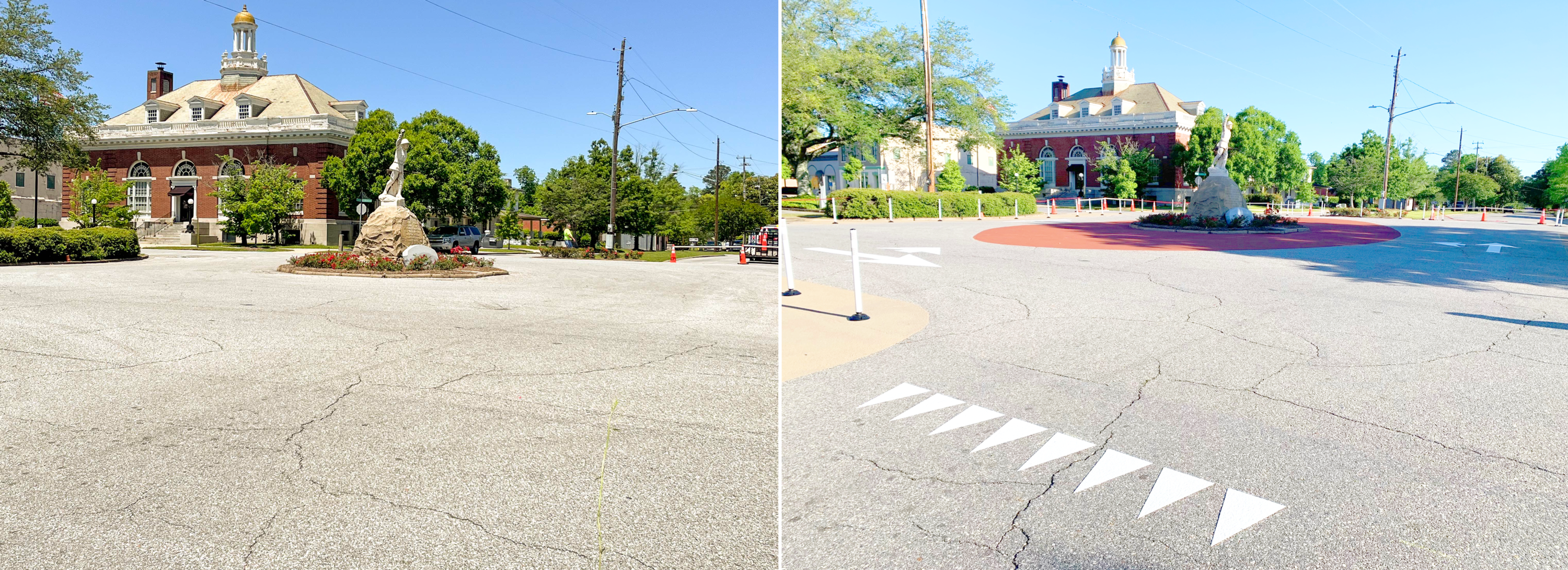
Community-Installed Roundabout, Eufaula, AL, US
Eufaula City Council, Main Street Eufaula, Barbour County Extension, Alabama Extension at Auburn University, Auburn University Civil Engineers, City of Eufaula Public Works Department, Youth Leadership Barbour County, Alta Planning
Eufaula, AL’s Historic Downtown is a vibrant hub of activity for the small community, where residents and out-of-town visitors shop, eat, visit trails, and play in the parks. However, the downtown intersections have awkwardly placed statues in the center, causing crashes, unsafe turning movements, and right-of-way confusion for pedestrians, cyclists, and motorists. In response, the interagency team worked to write an active transportation action plan for their community, which included a retrofitted roundabout design to make one of the main intersections safer for all users and improve the livability of the downtown area. Based on this plan, interagency team members personally painted a new roundabout circle, arrows, and crosswalk markings as well as installed bollards, planters and signs. All users now move seamlessly through the roundabout, with unsafe movements reduced by over 35% and bicycle ridership increased over 100%.

Pedestrian Safety Action Plan and Vulnerable Road User Safety Assessment, Statewide MD, US
Maryland State Highway Administration, Office of Planning and Preliminary Engineering (Maurice Agostino, P.E., Scott Pomento, P.E., Matt Baker, Kandese Holford, Molly Porter, AICP); Maryland State Highway Administration, Office of Traffic and Safety (Cedric Ward, P.E., PTOE, Lili Liang, P.E., PTOE, PTP, Sung Yoon Park, Ph.D., Jianyang Zheng, Ph.D., P.E.); AECOM (Denila Deliallisi, P.E., DBIA, Brian Lange); RK&K (Melissa Miklus, PLA, ASLA, Collin Hodges, AICP, Brad Deise, ASLA, Tristan Jackson, AICP); Kittelson & Associates (Jeff Riegner, P.E., PTOE, RSP1, AICP, Pete Jenior, P.E., PTOE, Jesús Cuellar, Tony Candelora)
Pedestrian and bicycle safety is an urgent issue in Maryland. The purpose of two companion documents, the Pedestrian Safety Action Plan (PSAP) and the Vulnerable Road User (VRU) Safety Assessment, is to make the state’s streets safer for everyone by making them safer for pedestrians and bicyclists. The PSAP, published in May, is part of the state’s Context Driven initiative, which approaches traffic safety by considering how land use interacts with Maryland’s transportation systems, with particular emphasis on the tradeoff between access and mobility. The PSAP used crash history, land use, and equity concerns to identify priority corridors for safety improvements. The VRU Safety Assessment, to be completed in November, went one step further by addressing local roads and broadening consultation efforts. As a result, Maryland has already completed more than 300 VRU safety projects and has programmed $97.5 million for additional improvements.
Coal Mine Avenue Crosswalk Improvement, Golden, CO, US
Jefferson County Transportation & Engineering Division (Kelly Dunne, P.E., PTOE, Traffic Operations & Planning Manager and Christina Lane, AICP, Senior Transportation Planner)
The Coal Mine Avenue Crosswalk Improvement serves to enhance pedestrian safety at the intersection of Coal Mine Avenue and Van Gordon Way in unincorporated Jefferson County, Colorado. With proximity to several K-12 schools and a regional park, pedestrian safety became a concern with students and nearby residents crossing Coal Mine Avenue consistently throughout the day. In its original configuration, the intersection lacked crosswalk enhancements and pedestrians were required to cross seven lanes of traffic.
A preferred design was selected after analyzing traffic data, reviewing pedestrian activity, and conducting public engagement. This design included Rectangular Rapid Flashing Beacons (RRFBs) as well as pedestrian islands and bump outs that reduced the number of lanes pedestrians must cross. Along with new striping, signage, and ADA-compliant directional ramps, the enhancements alert drivers to pedestrian activity and create a safer and more comfortable experience for those walking and wheeling across Coal Mine Avenue.
US-50/Chipman Road Bridge Replacement Project, City of Lee’s Summit, MO, US
MoDOT, City of Lee’s Summit
The US-50/Chipman Road Bridge Replacement Project was undertaken by the Missouri Department of Transportation (MoDOT) in close partnership with City of Lee’s Summit and Kansas City Scout to replace the US-50 bridges over Chipman Road in Lee’s Summit, Missouri.
This project became more than just replacing bridges, it transformed into an opportunity to improve safety for vehicular and pedestrian traffic. A sidewalk and a shared-use path were constructed under the bridge, through the interchange to provide pedestrian connectivity for businesses to the west and east of US-50. This also included new pedestrian signals and ADA compliant ramps at the interchange terminals. During the conceptual design, it was identified that pedestrian access crossing Chipman Road was insufficient.
A crosswalk was added at the Murray Road signalized intersection, improving pedestrian safety. The project was completed ahead of schedule with positive feedback provided from the traveling public, local stakeholders, and MoDOT.
Crosswalk Enhancements for School Crossings with RRFB and PHB, Roswell, GA, US
City of Roswell, In-House Traffic Signal and Traffic Sign and Marking Staff led by Derrick Crowder and Mike Elliot
The City of Roswell, GA is dedicated to promoting safety through our Speed Management and Pedestrian Safety Enhancement Program. Within the past year, we proudly introduced three Rectangular Rapid Flashing Beacons (RRFBs) equipped with enhanced lighting fixtures, one Pedestrian Hybrid Beacon (PHB), and several speed radar feedback signs.
This accomplishment was made possible by the expertise and dedication of our in-house personnel, including our skilled traffic signal, sign, and marking professionals. Through a timely planning and procurement, and efficient installation processes, we were able to enhance pedestrian safety in a cost-effective manner. Notably, two RRFBs now safeguard crosswalks near Vickery Mill Elementary School and Roswell North Elementary School, while the PHB serves the community surrounding Crabapple Middle School. We remain committed to ensuring the well-being of our citizens and continue to strive for excellence in our safety initiatives.
In evaluating the effectiveness of our crosswalk safety enhancements, we will consider a range of critical metrics. Foremost, our primary objective is the reduction of pedestrian crashes or near-misses at existing crosswalks, which not only enhances safety but also translates into cost savings related to injuries and fatalities resulting from these improvements. We plan to monitor pedestrian and driver compliance with crosswalk rules and track any reduction in vehicle speeds near crosswalks. Soliciting community feedback and increasing public awareness will also be integral to our strategy, ensuring that residents' perspectives are considered.
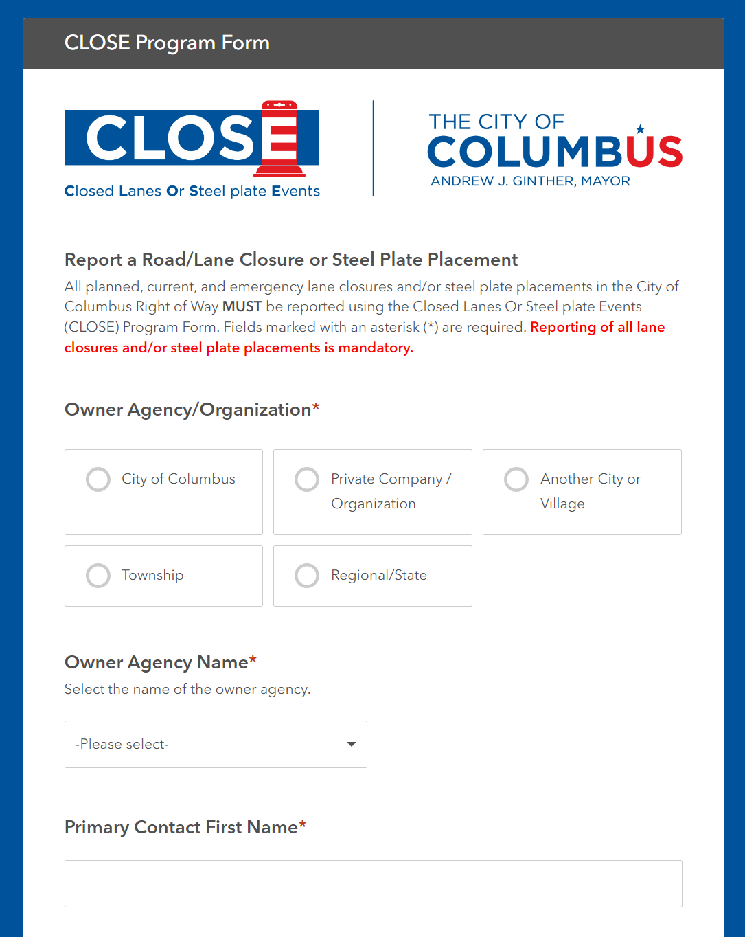
CLOSE Program (Closed Lanes Or Steel-plate Events), Columbus, OH US
Department of Public Service (DPS) Data Solutions & Compliance Group. Leads: Russ Bowerman and Kim Baillieul
The goal of the project is to establish a single, authoritative, active database for tracking closures within the Right of Way accompanied with user-friendly tools; promote participation and compliance with the program.
CLOSE has allowed for project planning, conflict detection, and safety analysis – with 261 roadway closures and 3,077 plates captured YTD. Having readily available 24-hour emergency contact information for all plates, especially during off-hours, has already proven beneficial; last December, a plate was knocked out of place around 3am, but staff were able to identify the plate owner and remedy the situation within minutes.

South Van Ness Quick-Build Project, San Francisco, CA, US
San Francisco Municipal Transportation Agency (SFMTA)
South Van Ness Avenue is on San Francisco’s High Injury Network, the 12% of city streets that account for over 68% of serious injuries and fatalities. The goal of the South Van Ness Quick-Build Project is to implement safety improvements to increase visibility, safety, and access to those who walk, bike, and drive on the corridor.
Project elements include: Road diet (reduced from four travel lanes to three with a center turn lane); Left turn pockets installed at intersections; Signal timing changes on South Van Ness Avenue between 14th Street and Cesar Chavez.

Ringling Trail Complete Streets, City of Sarasota, FL, US
The City of Sarasota, in collaboration with regional partners and stakeholders, has been at the forefront of advocating for enhanced multimodal transportation options. The Legacy Trail Extension, overwhelmingly approved by Sarasota County voters in 2018, serves as a pivotal catalyst for this initiative. The extension adds an additional 7 miles to the existing 11-mile corridor, thereby connecting Venice to downtown Sarasota. This extension is not merely a recreational path; it hosts over 500,000 trips annually, serving as a vital artery for commuters and recreational users alike.
The Florida Department of Transportation's SUNTRAIL plan further amplifies this need. The Gulf Coast Regional Trail, part of the SUNTRAIL, proposes a comprehensive loop through Sarasota and Manatee Counties, intersecting at downtown Sarasota. This necessitates a safe, efficient, and well-marked conduit for bicyclists transitioning from the Legacy Trail Extension to the barrier islands and beyond.
In 2019, the City Commission approved the Multi-Modal Connections Plan, which specifically identified Ringling Blvd as a potential complete street project. Public outreach was conducted in 2020, and the feedback was overwhelmingly in favor of protected bicycle lanes augmented with landscaping features. The City Commission subsequently approved the Basis of Design Report and Concept Plan in February 2021, with the dual aim of encouraging bicycling and stimulating economic activity in the downtown area.
2022 Projects
The Redesign of Saint-Jean Street, Roberval, QC, Canada
Jean-Luc Gagnon, Roberval City Engineer, Paul Mackey, MITE, Safestreet Inc., Guillaume Carrier, engineer at Tetra-Tech.
The project was designed in 2020, built in 2021 and was named Project of the Year by the Quebec Association of Municipal Engineers in Sept. 2022
The City of Roberval took advantage of a road rehabilitation project to improve the safety and comfort of pedestrians. Saint-Jean was a straight local street, near downtown, 800 meters (2,625 feet) long and 15 meters (49 feet) wide with only 650 vehicles per day, and a speeding issue. The street was narrowed to 9 or 11 meters (29.5 to 36 feet) with planting strips and lane striping, and crossing distances reduced by curb extensions and chicanes. Three local intersections became raised intersections, including one with a downgrade approach. Care was taken for sidewalk design, minimizing longitudinal slope, eliminating esthetic joints and installing tactile warning strips for the visually handicapped - features new to the area. Average speed was reduced by 15 km/h (9.3 mph). Trees were added in roadside, already improving the aesthetics; they should further help reduce speeds in the future. Pedestrian volumes have increased substantially.
Leading the Way to Zero With LPI, Tampa Bay, FL, U.S.
Peter Hsu (FDOT District 7 Safety Administrator); Ron Chin (FDOT District 7 Traffic Operations Engineer); Megan Arasteh (FDOT District 7 TSM&O Engineer); Dwayne Dempsey (FDOT District 7 Construction Liaison); Bala Padmanabhan (FDOT District 7 Consultant); Mark Hall (FDOT District 7 Consultant); Mahshid Arasteh (FDOT District 7 Consultant)
Beginning in early 2021 in an effort to reduce pedestrian and bicycle crashes at intersections, the Florida Department of Transportation (FDOT) District 7 Office, responsible for traffic safety and operations in the Tampa Bay region of Florida, set out an ambitious goal of installing Leading Pedestrian Intervals (LPIs) at 500 signalized intersections on state-maintained roadways. LPIs are an effective low-cost signal timing countermeasure that provides pedestrians with a minimum 3 second head start to begin crossing before vehicles are given the green indication. LPIs are proven to reduce pedestrian-vehicle crashes at intersections by 13% according to Federal Highway Administration (FHWA) studies. Fast-forward to late 2022, not only has District 7 reached their initial goal, but has already installed LPIs at over 700 signalized intersections successfully on State and Local roads. District 7 currently has 2/3 of LPIs implemented in Florida.
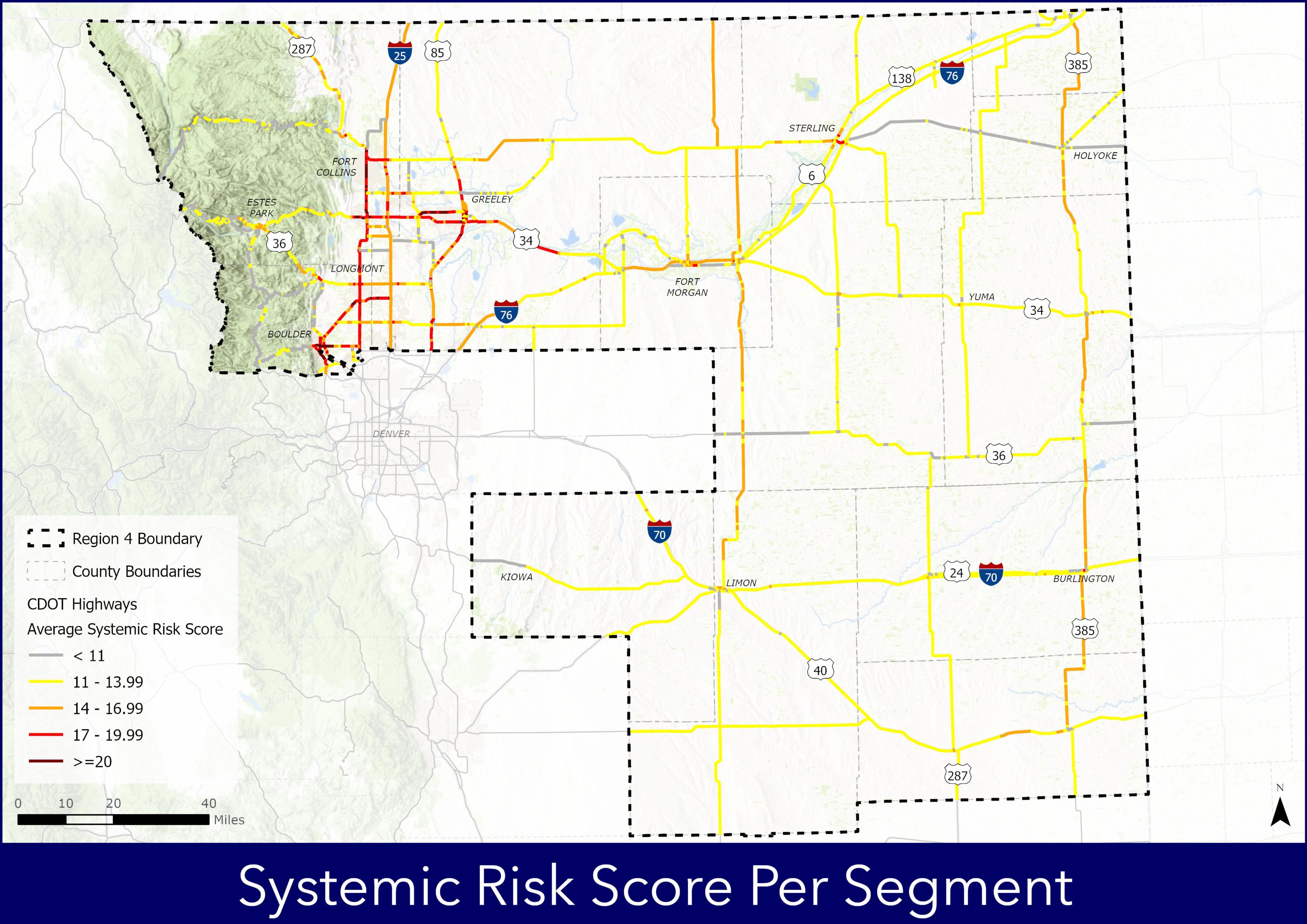
Region 4 Bicycle and Pedestrian Safety Study, Colorado Department of Transportation
The CDOT Region 4 Bicycle and Pedestrian Safety Study identifies areas of concern for bicyclists and pedestrians on the state roadway network based on available data to inform appropriate safety countermeasures, prepare concept designs, planning level cost estimates and benefit to cost ratios that could be used to support future safety grant applications and implement the improvements.
This study demonstrates a proactive approach to evaluating crash data. The process uses common road characteristics and crash patterns to systemically identify safety improvements across the network. The crash hot spot analysis and systemic countermeasure analysis produced ten top locations for innovative engineering countermeasures to reduce existing and potential crashes.
This project is leading the way for CDOT to prioritize bicycle and pedestrian improvements across the state. It is the first study of its kind in the State, and is now being replicated in CDOT Region 1.

Renovation of BYU College of Fine Arts and Communications, Provo, UT
Names of Organizations: Provo City, Utah Department of Transportation (UDOT) , and Brigham Young University (BYU)
Individuals Involved: Kaehan Shour (Transportation Engineer), Rob Hunter (Assistant City Engineer), Tim McCloud ( Traffic Electronic Specialist), and Preston Deuel ( Engineering Technician) all from Provo City
BYU’s college of fine arts and communications is going through a renovation. BYU decided to use Provo High School as a temporarily house for the college of fine arts and communications.
This change is making roughly 800 students to cross a high volume, high speed, main arterial road on daily basis. Provo City toke below short term measures to provide students with a safer crossing:
- Closed the second free flow lane to shorten walking distance.
- Installed proper signage to raise awareness.
- Installed two PHB’s with Pedestrian crossing buttons.
- Installed temporary rubber curbing to close the second free flow lane.
- Installed traffic delineators to raise awareness.
- Updated Striping.
Provo City has also taken below measures as a long term solution to provide students with a safer crossing:
- Applied for Safe Streets for All (SS4A) grant.

SEE AND BE SEEN Active Transportation Safety Campaign, City of Lancaster, CA
The City of Lancaster’s SEE AND BE SEEN active transportation safety campaign works to educate residents on being safe drivers, bicyclists, and pedestrians.
East Side Pedestrian Safety and Mobility Project, City of Stamford, CT
Names of Organizations and Individuals Involved: City of Stamford Transportation Bureau. Luke Buttenwieser and Frank Petise, P.E
The Stamford Transportation Bureau’s East Side Pedestrian Safety and Mobility Project is broken down into three phases.
1) Construct 23 new pedestrian ramps to full ADA compliance. Convert two intersections into all-way stops and paint crosswalks across all four sides of those intersections.
2) Upgrade two existing uncontrolled crosswalks crossing Route 1 with RRFBs, ADA compliant Curb Ramps, and pedestrian refuge islands.
3) Construct a new sidewalk connecting a Stamford Housing Authority Project to a bus route and another main road in Stamford.
Background information on project selection:
- The project is located in Census Tract 218.02 is a federally designated Historically Disadvantaged Community.
- 10% of households in this census tract do not own a car
- 7% of residents in the census tract have some sort of disability
- This section of Route 1 is a high speed and crash corridor

Vision Zero Plan Utilizing Six "Es": Engineering, Education, Emergency Services, Enforcement, Equity, and Evaluation, Anne Arundel County, MD
We recently completed a Vision Zero Plan that focuses on creating programs utilizing six "Es," Engineering, Education, Emergency Services, Enforcement, Equity, and Evaluation, to reach zero deaths and serious injuries on our roads. You can view the plan at our website here:
Recently, we worked with the Baltimore Metropolitan Council (BMC) who is leading an education campaign called "Look Alive" throughout the Baltimore Region to bring the campaign into the County. The campaign included "street teams," (see pictures below) wearing sign backpacks that make themselves visible at high pedestrian or bicycle traffic areas to educate all road users to be aware of pedestrians and bicyclists and to encourage safe walking and cycling practices." I have attached a few pictures from earlier this month when the street teams were out and about near our offices and the high school next door.
The campaign is fully funded by a grant from the State to BMC and supports the Vision Zero Initiatives both the State and County have adopted, the State by legislation in 2019, and the County, by resolution early this summer 2022.
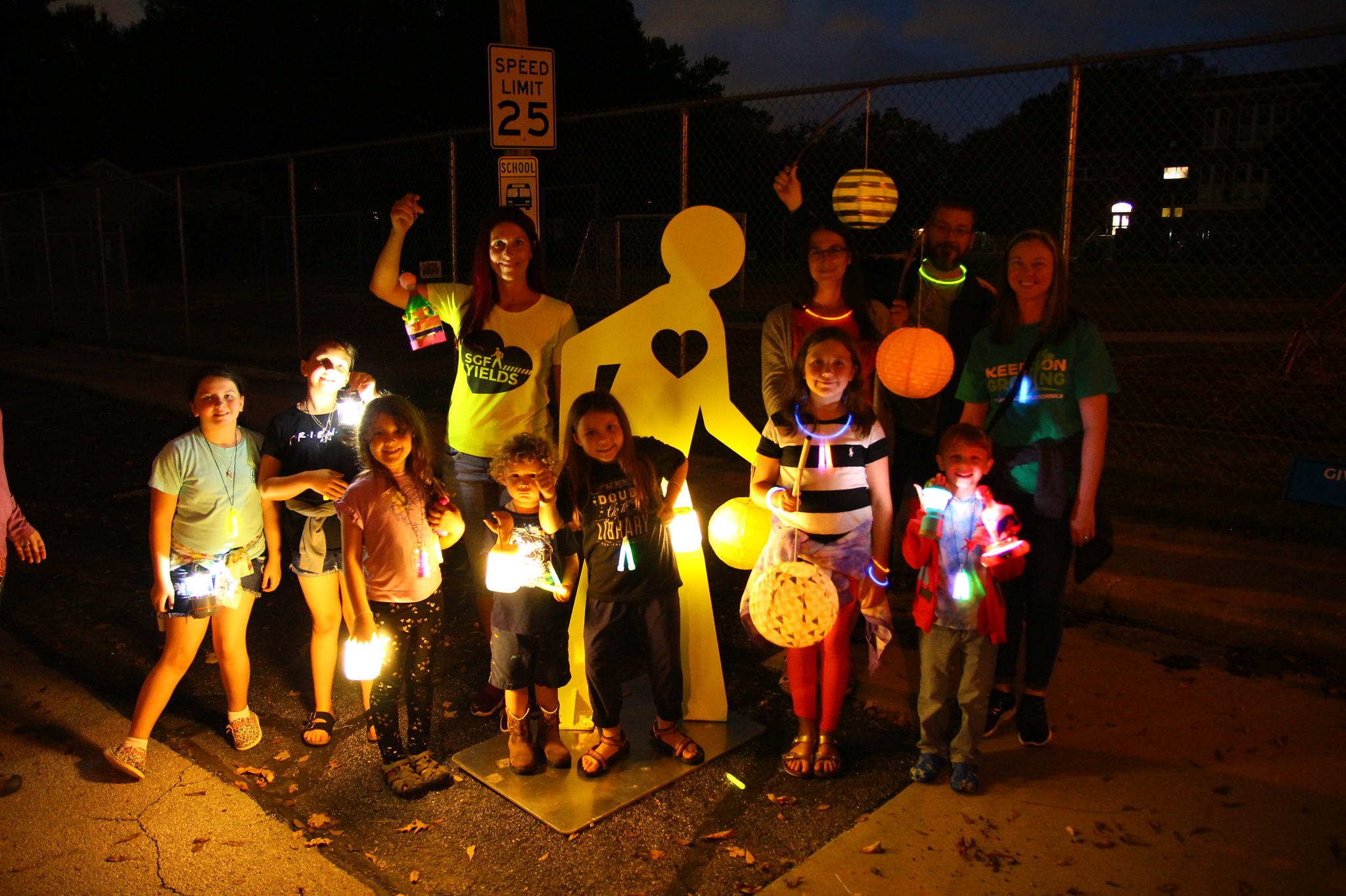
SGF Yields - Pedestrian Safety Program, Springfield, MO
Springfield, MO has a robust pedestrian safety campaign called “SGF Yields”. This year, Springfield worked with five neighborhoods to organize the 2nd annual Lantern Walk.
The event is held on the first Saturday in October and promotes pedestrian awareness in fun way: Residents and elementary schools are encouraged to build lanterns with their children and come out for a one mile Lantern Walk. Neighborhood volunteers staff booths along the route where families stop and learn about crosswalk safety. Children learn about safe walking habits and parents are encouraged to actively practice pedestrian safety with their kids: Leading by example and engaging their kids in the decision-making process. Adults also receive driver focused pedestrian safety tips and rules. Families collect educational flyers along the way, reflective key chains and other goodies.
This year, Springfield Mayor Ken McClure kicked off the Lantern Walks by declaring October as Pedestrian Safety Month for Springfield.

Improving Pedestrian and Bike Access and Safety near University of Florida, City of Gainesville, FL, U.S.
Name of Agencies: City of Gainesville, University of Florida, Florida Department of Transportation
Individuals: Jesus Gomez, Director of Department of Transportation, City of Gainesville; Deborah Leistner, Transportation & Parking Manager, City of Gainesville; Emmanuel Posadas, Traffic Operations Manager, City of Gainesville; Scott Wright, Planner, City of Gainesville; Subhadipto Poddar, Engineer and Utility Designer, City of Gainesville; Robert Schenck, ITS, CV, and AV Program Manager, City of Gainesville
A challenging task in a university town is maneuvering multimodal transportation safely in and around campus without jeopardizing overall mobility along major corridors. In Gainesville, W University Avenue, a major constrained corridor that carries over 20,000 vpd abuts UF campus. Over a 3 year period (2016-2018) 150 crashes occurred at 4 intersections accessing campus, of which 79 resulted in severe injuries and 1 death; up to 864 pedestrians cross each of these intersections daily during midday peak times. The Gainesville Transportation Department in collaboration with UF and FDOT converted the 4 corridors along University Ave into one-way pairs with protected bike facilities, bike signals, and leading pedestrian intervals; the project also removed turn movements along University Ave reducing the number of conflicts between the different modes as part of the City’s Vision Zero strategy. The safety effort continues with the application of video detection and research into predictive crash analysis.
Citywide Traffic Signal Optimization Program, Washington, DC, U.S.
Project: Citywide Traffic Signal Optimization Program (Round 2)
Public Agency: District Department of Transportation (DDOT)
Prime Consultant: Mead & Hunt

Local Pedestrian-Focused Road Safety Assessments, Fairfax County, U.S.
Dr. Melicent Miller, Virginia Department of Health (VDH); Stephen Read, P.E., Virginia Department of Transportation (VDOT); Fairfax County, Virginia; Equitable Cities; VHB (Vanasse Hangen Brustlin)
In 2021, the Virginia Department of Health (VDH) and the Virginia Department of Transportation (VDOT) partnered to facilitate local pedestrian-focused Road Safety Assessments (RSAs). The RSAs targeted communities that were past participants in the Virginia Walkability Action Institute (VWAI) and along roads identified as VDOT Pedestrian Safety Action Plan (PSAP) priority corridors. The RSAs followed a unique approach - developed by the Prioritizing Active Transportation Health and Safety in Virginia (PATHS) collaboration- including an interdisciplinary team of planners, engineers, public health practitioners, and community advocates. Implementation of recommendations from the RSAs is underway, such as the Backlick Road and Amherst Avenue improvement in Fairfax. The Virginia Highway Safety Improvement Program (VHSIP) is funding proven safety countermeasures such as pedestrian signal push buttons, leading pedestrian intervals, and warning signage as a result of the RSA. Visit the PATHS website for more information on VWAI, RSAs, and this multi-sectoral initiative.

Improving Pedestrian Safety, City of Cornelius, OR, U.S.
Organizations: ODOT, City of Cornelius, Centro Cultural, and Virginia Garcia Clinic
The Oregon Department of Transportation and City of Cornelius leaders took a major step toward making a safer community for everyone Friday by inaugurating a new rectangular rapid flashing beacon that speaks both Spanish and English to pedestrians on Tualatin Valley Highway. The new beacon will serve the growing multi-cultural Cornelius community and improve safety along the busy highway. The RRFBs have become an increasingly familiar sight on state and local roads. They improve safety by allowing pedestrians to activate flashing amber lights that alert oncoming motorists to people preparing to cross the road. ODOT started using pedestrian activated beacons on Portland area roads a decade ago and has found them an effective tool for improving safety on busy corridors, especially in areas with long distances between traffic signals. The new Cornelius beacon is part of a continuing effort by ODOT, the City, Centro Cultural and Virginia Garcia Clinic to improve safety and integrate equity into design and construction of projects.
2021 Projects
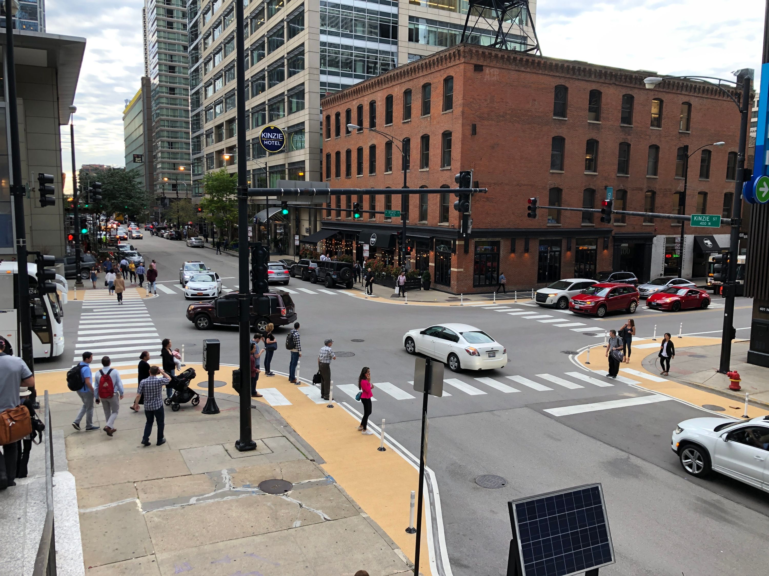
Improvement to High Crash Corridor Along State Street, Chicago, IL, U.S.
Chicago Department of Transportation, Sam Schwartz, Civiltech Engineering, Alderman Brendan Reilly
The Chicago Department of Transportation (CDOT) implemented a rapid delivery project at six intersections along State Street, which was designated a High Crash Corridor in Chicago's Vision Zero Action Plan. State Street is a commercial corridor in Chicago’s central business district with heavy pedestrian activity. In Fall 2019, CDOT installed paint-and-post curb extensions, pedestrian refuge islands, crosswalk striping changes, and hardened centerlines along the corridor. CDOT made these improvements based on the recommendations of the Vision Zero Downtown Task Force, which included area stakeholders and elected officials. In addition, the CDOT Vision Zero team collected extensive data before the project was implemented, including vehicle speeds, vehicle turning radii, and yielding behavior. Data collection after the project installation and analysis of results is forthcoming.
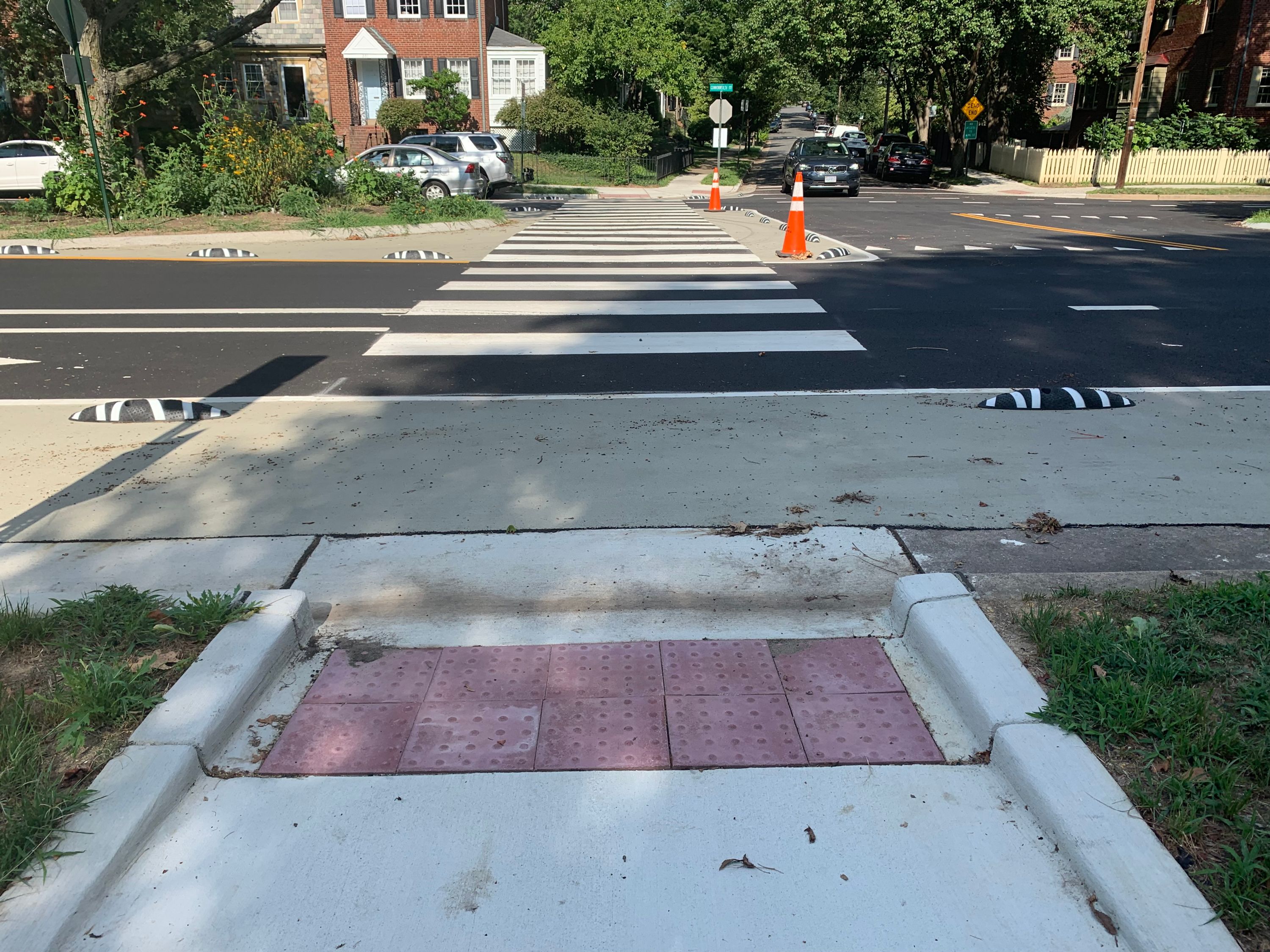
Painted Curb Extensions on Commonwealth Avenue, City of Alexandria, VA, U.S.
Ensuring safety of people walking is a critical part of the City’s efforts to eliminate fatal and severe crashes, as pedestrians are among the most vulnerable users of the roadway. In 2017, the City completed walk audits for all elementary schools and identified recommendations to improve safety for students walking and biking to school. Recently, the City implemented several recommendations on Commonwealth Avenue by installing painted curb extensions, median refuge areas, high-visibility crosswalks, pedestrian warning signage, and narrower vehicle lanes. These treatments calm traffic, slow vehicle turns, increase visibility of pedestrians, and reduce the distance people must cross. These improvements reduced crossing distances for pedestrians by up to 70 percent. Additionally, the City recently installed a Pedestrian Hybrid Beacon, high-visibility crosswalk, and pedestrian refuge area at the intersection of Braddock Road and North Early Street, near Alexandria City High School’s Minnie Howard Campus.
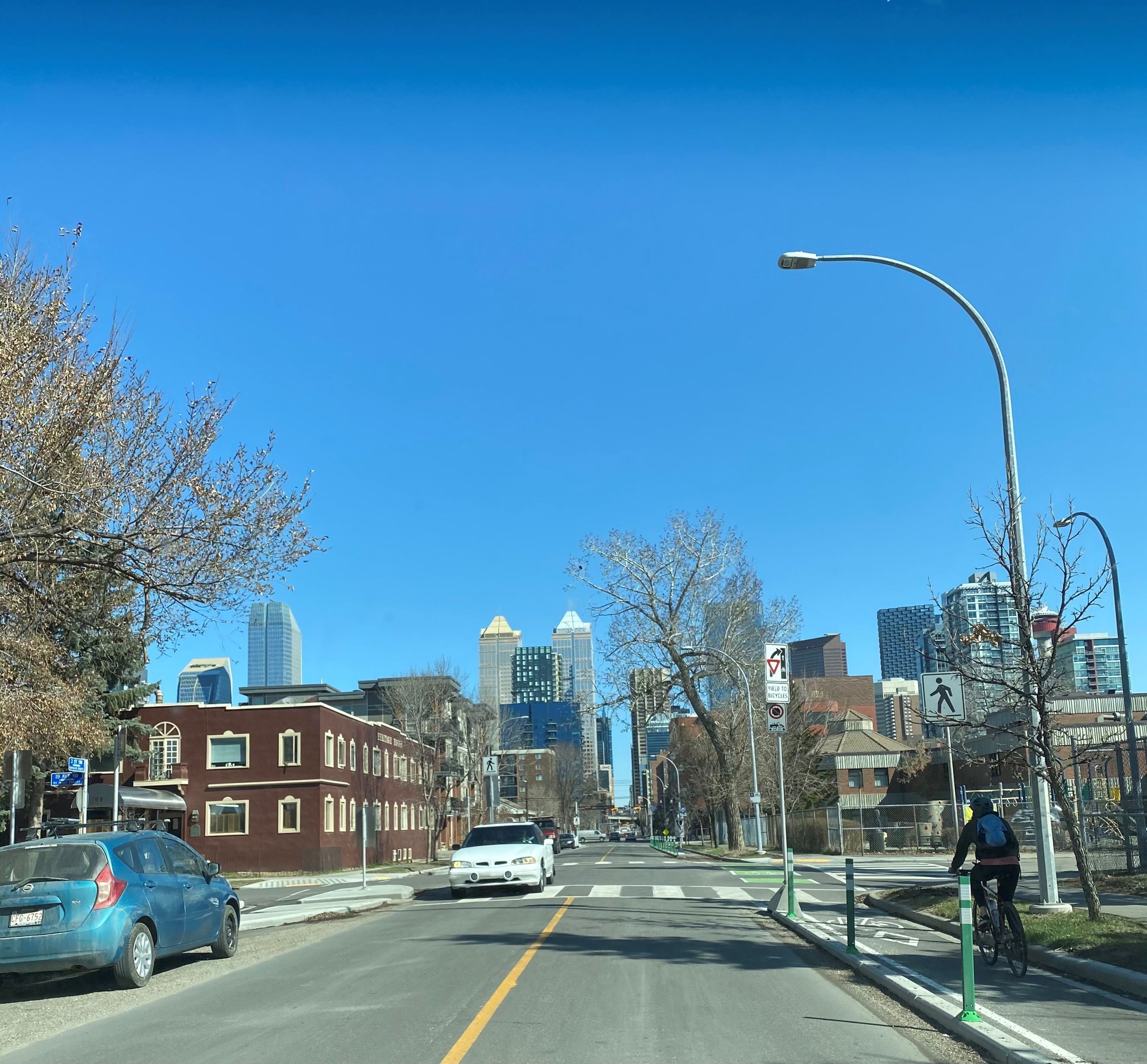
2 Street S.W. Complete Streets, City of Calgary, AB, Canada
City of Calgary staff including Alex Saba, Anne Cataford, Cherise Stock, Samad Abdul, Katherine Glowacz, Tom Thivener, Blanka Bracic, and contractor Aecon
The City of Calgary successfully completed the 2 Street S.W. Complete Street project in 2020, upgrading facilities for pedestrians and cyclists. Based on public feedback, designs were refined to reflect the needs of those who live, work and travel in the area.In addition to new protected and delineated bike lanes for cyclists, improvements to pedestrian infrastructure included:
- Installation of new curb extensions to slow traffic and enhance the safety of people crossing the road
- Rehabilitation of deteriorated curbs, sidewalks, and ramps
- Installation of Rectangular Rapid Flashing Beacons, additional accessibility ramps and a new traffic signal
As a central residential and commercial district, these changes have improved livability in two of Calgary’s popular neighbourhoods by enhancing connectivity and access to key destinations in the area. Improved safety and accessibility for people walking and wheeling demonstrate The City of Calgary’s commitment to improving multi-modal infrastructure.
Active and Safe Routes to School, City of Calgary, AB, Canada
City of Calgary staff including Monique Castonguay, Jacquelyn Oriold, Meredith Truman, Tony Churchill, Surendra Mishra, Katherine Glowacz; EverActive Schools, Calgary Board of Education and Calgary Catholic School District.
The City of Calgary’s Active and Safe Routes to School program uses a multi-pronged approach, focused on coordinating engagement and education with any needed engineering improvements and enforcement to support immediate and longer term increases in active school travel.
This coordinated approach is internationally recognized as more effective at changing travel behaviours than applying measures independently. Through the program, The City of Calgary partners with schools, community, and provincial organizations to build a culture of active travel in schools as well as implement infrastructure improvements.
Program outcomes include:
- Addressing verified travel safety issues in school walk zones and implementing capital enhancements such as curb extensions, signage changes and building missing transportation links.
- Encouraging children to use active travel modes for travel to/from school by observing existing behaviour (walk-abouts), developing and executing plans to change behaviour, celebrating success, and monitoring effectiveness over time.
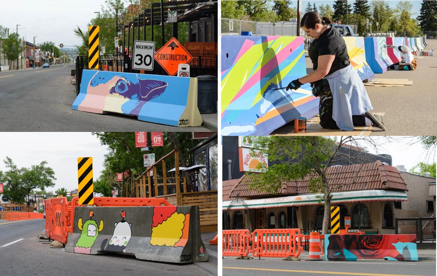
Patio Mural Barriers – Collaboration with Beltline Urban Mural Project (BUMP), City of Calgary, AB, Canada
City of Calgary staff including Andrew Sedor, Ravi Seera, Kennith Lin, Merle Jensen, Uanna Chudyk; Beltline Urban Murals Project and City Council (Ward 8) staff
Indoor dining was unsafe and restricted during durations of the COVID-19 pandemic. Restaurants across Canada worked with municipalities to create outdoor patio dining extensions in order to support local businesses. As of July 13, 2021, 188 restaurants in Calgary have a seasonal patio extension. The patio extensions have allowed businesses to expand their seating capacity increasing their ability to generate revenue and has also brought a new vibrancy and outdoor dining culture to Calgary.
While the seasonal patios are popular, there are areas for improvement including aesthetics and enhanced protection for pedestrians and restaurant-goers. To improve aesthetics and safety in 2021, The City of Calgary worked with local non-profit BUMP (Beltline Urban Mural Project) to have local artists paint 30 concrete barriers at the front of patio walkways. The painting of the barriers supported nine local artists financially and showcased their work.

Merrimac Way Active Transportation Improvements, City of Costa Mesa, CA, U.S.
Agencies/Organizations Involved: City of Costa Mesa, Orange Coast College, Southern California Association of Governments (SCAG), Caltrans Active Transportation Program, City’s Bikeway and Walkability Committee
City’s Project Team included: Raja Sethuraman, Public Services Director; Jennifer Rosales, Transportation Services Manager; Ramin Nikoui, Associate Engineer; Seung Yang, City Engineer; Naz Mokarram, Senior Engineer
The Merrimac Way Active Transportation Improvement Project implemented innovative pedestrian safety improvements. The project includes the first cycle tracks in the City, multiuse paths for pedestrians and bicyclists, and a midblock pedestrian/bicycle crossing with a pedestrian hybrid beacon (HAWK). The multi-use paths are separated from adjacent vehicles with landscaping, and the cycle tracks on both sides of Merrimac Way provide a buffer between vehicles and pedestrians. The project included a reduction in travel lanes, street rehabilitation, median realignment, landscaping, green bicycle conflict striping, and ADA improvements. The design was completed in 2020 and construction completed in August 2021.
Historically, the City received speeding complaints on Merrimac Way from adjacent residents and Orange Coast College (OCC) staff and students. City engaged the community to identify safety improvements on Merrimac. In 2018, Costa Mesa partnered with SCAG and OCC to host a demonstration of proposed improvements and incorporated feedback into final design.
.jpg)
Third Street Pedestrian Safety Operational Improvements, City of St. Petersburg, FL, U.S.
The City of St. Petersburg, FL: Evan Mory, Director, Transportation & Parking Management; Brejesh Prayman, Director, Engineering & Capital Improvements; DiAnna Rawleigh, Director, Stormwater, Pavement, and Traffic Operations; Cheryl Stacks, Transportation Manager; Lucas Cruse, Bicycle Pedestrian Coordinator; Evan Birk, Engineering Design Manager; Michael Gebler, Senior Capital Projects Coordinator; Sharon Heal-Eichler, Landscape Architect; Michael Kirn, Capital Projects Coordinator; Todd Berry, Traffic Signals Supervisor; Kevin Jackson, Traffic Signals Coordinator; Michael Frederick, Neighborhood Transportation Manager
Florida Department of Transportation (FDOT) and consultants: Peter Hsu, FDOT District 7 Safety Engineer; William Riha, FDOT District 7 Safety Program Manager; Ginger Regalado, FDOT District 7 Bicycle and Pedestrian Program Manager; Julie Scanlon, FDOT District 7 Traffic Signal Operations Manager; Daniel Hendrickson, Burgess & Niple, Inc.; Sarah Tarrant, Florida Safety Contractors, Inc.; Pete Yauch, Iteris, Inc.
The City of St. Petersburg partnered with the Florida Department of Transportation for pedestrian safety improvements along Third Street through the city’s downtown. The State Road is a one-way street that serves as a primary vehicular route, though presents a challenge for pedestrians in an active, urban environment. The $1.85M project created curb extensions at eleven intersections to reduce pedestrian exposure while also slowing motorists’ turns. The curb extensions were intentionally designed to allow for striping modifications to provide consistent, narrow vehicle lanes at the intersection approaches for improved safety. Following construction, operational improvements were also performed to retime traffic signals along the corridor to incentivize motorists to drive at the target speed, not more than 30 mph, while also introducing Leading Pedestrian Intervals based on the new, shortened crossing distances. The newly-completed project is expected to reduce crashes by 37% based on the Crash Reduction Factors of implemented changes.
Improving the Pedestrian Experience at Signalized Intersections, City of Stamford, CT, U.S.
City of Stamford, CT Transportation, Traffic & Parking Department; Frank Petise, Stephen Frycz, Luke Buttenwieser
The City of Stamford is currently in the planning stages of a transformative pedestrian focused infrastructure project to upgrade all pedestrian facilities at the 211 municipal owned traffic signals. This project is meant to be all encompassing of the pedestrian experience at signalized intersections (which makes up a significant majority of pedestrian crossing locations in the City). The project will upgrade all pedestrian ramps, add pedestrian signals where none exist and upgrade existing ones, add missing crosswalks, upgrade all push buttons to APS buttons, and analyze timings to install LPI, concurrent phasing, ensure proper crossing time, and putting more signals on recall. When we upgrade the pedestrian facilities with proven safety measures at our signalized intersections there’s a significant improvement for pedestrians and other users as well. The project will touch every neighborhood in the City and be one of Stamford’s most far-reaching and impactful infrastructure projects.

Raised Pedestrian Crossing with Bike Diversion, City of Thornton, CO, U.S.
Organizations: City of Thornton, Thornton, CO Olsson Engineering, Loveland, CO Goodland Construction, Inc., Golden, CO Individuals: Matthew Layman, PE Civil Engineer, City of Thornton
A raised pedestrian crossing with bike diversion was constructed near an elementary school in August 2021. The street is a residential collector with a regional trail crossing that serves as a main crossing point for the school. The street is 44’ wide, with bike lanes and parking lanes, with speeding being identified on the street. Conversations were held with the school district regarding safety concerns during the school drop-off and release times. Vehicles parked too close or blocked the crosswalk making students and other pedestrians cross between vehicles creating unsafe conditions. This project constructed a raised pedestrian crossing with curb extensions narrowing the roadway to 20’ while still maintaining a bike lane in each direction by shifting the lanes to the edge of curb. These improvements increased pedestrian visibility, reduced pedestrian time in active travel lanes while crossing, reduced vehicle speeds, and maintained the multi-model layout of the neighborhood.

Pedestrian Safety Accommodations Along State Route 1, Towns of Dewey, Bethany, and South Bethany, DE, U.S.
Through a collaborative effort between DelDOT and the popular resort towns along Delaware’s coastline, extensive pedestrian safety accommodations were implemented along the SR 1 corridor over the past two years. In the Town of Dewey Beach, a pavement rehabilitation project was utilized to construct a host of pedestrian upgrades from a recent pedestrian safety audit, including 31 curb bump-outs, eight RRFBs at uncontrolled crosswalks, ADA upgrades for signalized crossings, and installation of Delaware’s first two-stage left-turn bicycle boxes. Further south, DelDOT partnered with the Delaware State Police and the Towns of Bethany Beach and South Bethany to implement $2+ million in pedestrian improvements, including continuous roadway lighting along a 3-mile stretch of SR 1 and nine RRFB crossing systems. The improvements were well received by the communities and displayed how teamwork between state and municipal agencies can lead to quick-win results and a safer environment for pedestrians and bicyclists alike.
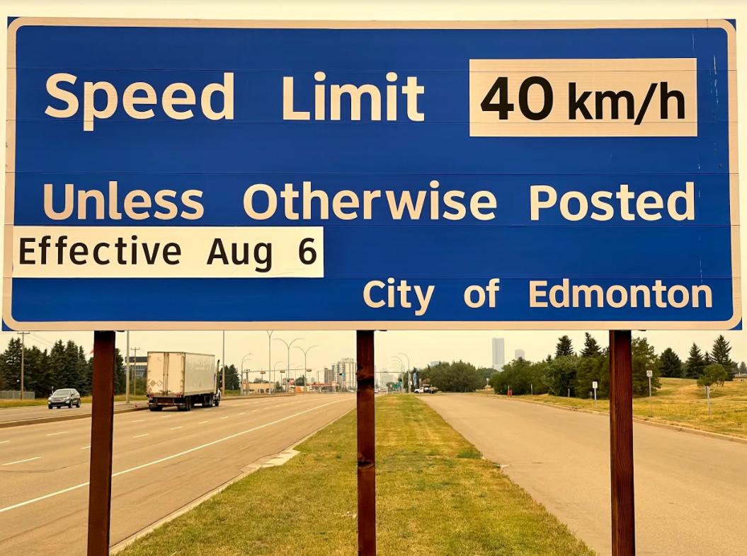
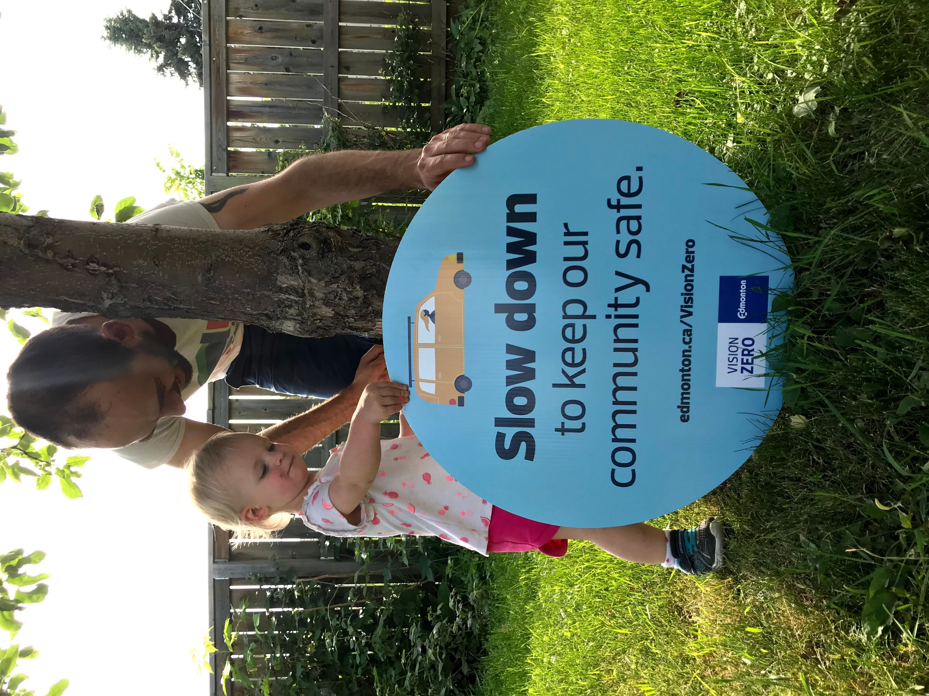
Speed Limit Reduction on Residential and High Pedestrian Activity Streets, City of Edmonton, AB, Canada
Organizations, agencies, and individuals involved: City of Edmonton and Edmonton Police Service
In order to increase safety and livability in residential and high pedestrian areas, the default speed limit in Edmonton changed from 50 km/h to 40 km/h on August 6, 2021. Slowing down gives people more time to react to the unexpected to prevent crashes and reduce the severity of collisions that do happen. Reducing speeds creates a more comfortable environment for active modes of transportation, builds community trust and creates livable neighbourhoods. Data from active automated enforcement sites on roads with the new default speed limit from August 6 to September 1 indicates that the majority of drivers are complying with the new speed limit. During 1266 hours of enforcement in 40 km/hr zones, two to three violations were captured on average per hour. 76% of drivers were following the new rules.
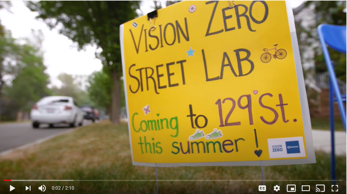
Vision Zero Street Labs, City of Edmonton, AB, Canada
City of Edmonton
Vision Zero Street Labs is a community activation program which launched in Spring 2021 as a key action in the Safe Mobility Strategy (2021 - 2025). Street Labs are temporary, community-led, customized, creative, and flexible solutions to address neighbourhood traffic safety concerns. The program creates an opportunity to trial traffic safety solutions on residential streets with temporary, adaptable materials. A Street Lab could convert a block to a shared street, add parklets to narrow sections of the road to slow traffic, install curb extensions to shorten a crossing distance, or paint a crosswalk to increase visibility. edmonton.ca/StreetLabs
Safe Speeds Toolkit, City of Edmonton, AB, Canada
City of Edmonton
The Safe Speeds Toolkit is a community activation program which launched in Spring 2021 as a key action in the Safe Mobility Strategy (2021 - 2025). Edmontonians can use the Safe Speeds Toolkit to address concerns about speeding in their neighbourhood and support the implementation of the new 40 km/h default speed limit, which came into effect on August 6, 2021. Available tools include portable driver feedback signs, creative signage, information to educate and communicate about speeding issues, and a mechanism to request automated enforcement presence. edmonton.ca/SafeSpeedsToolkit
Improving Safety at Schools, City of Edmonton, AB, Canada
City of Edmonton
To address school safe mobility issues, the City established a School Traffic Safety Committee in 2016 to better integrate and collaborate with school stakeholders. The School Traffic Safety Committee includes members from the City of Edmonton, school boards, the Edmonton Police Service, Alberta Motor Association and more. Safe mobility is reviewed at schools each year, and when potential problems are identified, engineers identify countermeasures tailored to each school’s experience. By the end of 2020, 237 schools were upgraded in order to increase safety through this program and 48 schools were reviewed in 2020 for upgrades in 2021. Improvements include all marked crosswalks converted to zebra crosswalks, yield signs replaced with stop signs, yellow centre line pavement marking added if the roadway was wide enough, retro-reflective sleeves added for stop sign and crosswalk poles to increase visibility, flashing beacon added at the crosswalk for each school if there was not one already.
Vision Zero School Kit, City of Edmonton, AB, Canada
City of Edmonton
Vision Zero School Kits help create safer streets and more livable communities in Edmonton. Street safety around schools is essential to help protect our most vulnerable road users and is a key action of the Safe Mobility Strategy 2021-2025. When neighbourhood streets are safe, parents, guardians, children and caregivers are more likely to walk and bike to school, use playgrounds, and enjoy local parks thus supporting healthy and vibrant communities. The Kit includes centreline signs (up to two per school) and lawns signs to encourage safe driving behaviours, activities for teachers and students to work together to create vibrant crosswalks and student-designed signage, and resources to learn more about street safety in Edmonton. The Vision Zero School Kit can be used to help build street safety awareness around schools and create new experiences and conversations to contribute to more livable neighbourhoods.
Shared Streets and Mobility Lane, City of Edmonton, AB, Canada
City of Edmonton
Shared Streets and Mobility Lanes are one way we can help everyone stay safe and comply with Alberta Health Services physical distancing guidelines. This work was initiated in Spring 2020, as we adapted to the COVID pandemic. Shared Streets are open for people to use to bike, walk, or other active modes. Since all modes are using the same space with a Shared Street, the speed limit is reduced to 20 km/h. Mobility Lanes open the use of a vehicle lane for people to use for physical activity by closing the lane to vehicle traffic and reducing speed limit to 40 km/h. The locations for 2021 were selected based on population density, pedestrian activity, type and design of the road, safety as well as feedback and data from the 2020 implementation. These temporary installations will be maintained until late Fall 2021.
Busch Boulevard/S.R. 580 - 3’s for Pedestrian Safety
Agencies and Individuals: City of Tampa; Hillsborough County; Ginger Regalado – FDOT District 7 Pedestrian and Bicycle Program Manager; City of Temple Terrace; Bike Walk Tampa Bay – Education Efforts; Hillsborough County Sheriff’s Office and Tampa Police Department – Enforcement Efforts
The Florida Department of Transportation and agency partners deployed a multi-disciplinary approach along Busch Boulevard, a high priority corridor for pedestrian safety, consisting of Engineering, Education and Enforcement countermeasures. The 3 E’s of safety are a powerful strategy aimed at reducing fatal and serious injury crashes when applied in combination.
Engineering countermeasures included providing pedestrian refuge islands and traffic separators, upgrading lighting to LED, providing speed feedback signs, and implementing context sensitive signal timing along corridor segments with history of speeding. Lastly, four Pedestrian Hybrid Beacons (PHB) were constructed and protected left turns and extended walk times were implemented in areas near schools and high pedestrian activity.
Education efforts included on-street education of over 200 drivers, pedestrians and bicyclists, business outreach, and on-site education of high school students. Lastly, Enforcement efforts included issuance of warnings and citations as well as distribution of safety materials including bike lights.
First Multiple Corridor Wide Plan for SUPs, Fort Worth, TX, U.S.
Agencies and Organizations: Texas Department of Transportation (Fort Worth District, Design Division and Environmental Affairs Division); Federal Highway Administration; North Central Texas Council of Governments; City of Arlington; City of Forest Hill; City of Fort Worth; City of Kennedale; Fort Worth Bicycle Assn.; Historic Carver Heights Neighborhood Association; Lone Star Cyclists Bike Club; Streams and Valleys, Inc.; Village Creek Neighborhood Association
Individuals: Curtis Loftis, P.E. (TxDOT Fort Worth); Chad Putnam (TxDOT Fort Worth); Naser Abusaad, PE, AICP (Civil Associates, Inc.)
Spanning 16 miles and four cities, the Texas Department of Transportation (TxDOT) Fort Worth District’s Southeast Connector (SEC) planning study focused on I-20, I-820, US 287 and multiple interconnecting cross streets. These highly traveled corridors include limited pedestrian and bike facilities and connectivity links to municipal bike trails. Challenges included conflicting municipal bike plans and emerging, yet unfinalized Federal Highway Administration and TxDOT pedestrian/cyclist safety advancement guidelines.
Proactively engaging these challenges through the stakeholder agency and community outreach program and consensus-building with neighboring residents, nearby schools, and local cycling leaders produced a continuous multi-modal system plan of Shared Use Paths (SUPs) throughout the corridors with integrated cross-street bridges and ADA intersection crossings. The SEC study approved in September of 2020 pioneered the Fort Worth District’s first multiple corridor wide plan for SUPs which will integrate and holistically link local bike and Regional Veloweb routes and transit stops.
Safety and Visibility of Pedestrians Crossing Jefferson Avenue, Grand Rapids, MI, U.S.
Mercy Health – Adam W. Rogalla, Facility Manager; Strain Electric Co. – Todd Strain, Debbie Strain; Kamminga & Roodvoets – Ian Martin; City of Grand Rapids: Mobile GR Department – John Bartlett, P.E., Traffic System Engineer; City of Grand Rapids Engineering Department – Rick DeVries, Jeff McCaul, John Wiles, Downtown Grand Rapids Inc. (DGRI) – Mark Miller; Progressive AE – Chris Zull, Dan Grover, Karl Kowalske, Dan Westenburg, Kristin Carter, Robert Dolweck
Mercy Health Saint Mary’s Campus is conveniently located in the heart of downtown Grand Rapids, MI, between Cherry and Wealthy Street on Jefferson Avenue. In early 2020, Mercy Health identified a safety concern for pedestrians crossing Jefferson near Maple Street. Due to recent accidents, the safety and visibility of pedestrians crossing Jefferson Avenue needed to be improved, especially since the crossings are used primarily by hospital staff and patients.
The crosswalk at Maple Street was improved by adding a Solar Engine Rectangular Rapid Flashing Beacon (RRFB) to the existing W11-2 & W16-7P signage, and sidewalk ramps were upgraded to current ADA standards for pushbutton landings. The safety of the mid-block crossing to the South of the RRFB was increased by adding a Redipave Modular Median Pedestrian Refuge Island. The Solar Engine RRFB and recycled truck tire Modular Median make safer, sustainable, pedestrian crossings across Jefferson to Saint Mary’s.

Sinai Rd Pedestrian Lane Project, Halifax, VA, U.S.
Gerry Harter, P.E., PTOE, (M), Past VASITE Chapter President; Siavash Mousavizadeh, P.E., (M); Matt Conner, P.E., (M); Jay Craddock, P.E.; Chris Winstead, P.E.; Kenneth Martin, P.E.; Susan Keen, P.E.; Brian Casto, P.E.; George Rogerson; Glenn Singleton; Vincent Hunter; James Holt
The Sinai Road Pedestrian Lane project was an innovative multi-use facility on a two-lane rural high volume roadway in Halifax, Virginia. This project provided safe interconnectivity between minority/low-income neighborhoods and the only retail convenience store in this rural area by paving shoulders, shifting traffic, adding a curbing/bollard system, and by adding a dynamic flashing light crossing system which provided a solution that immediately benefited users.
The total project cost, at approximately $225,000, was a significantly lower cost solution than a traditional curb/gutter/sidewalk option which would have cost well over 3 million dollars and had right-of-way and environmental impacts. While at a fraction of the cost, this project still improved pedestrian safety and convenience. The main portion of this project (Pedestrian Lane) took approximately 2 months to construct. This is the first pedestrian lane of this magnitude installed by the Virginia Department of Transportation (VDOT).
Pedestrian Safety Improvement Program (PSIP), Ohio, U.S.
Ohio DOT’s Pedestrian Safety Improvement Program (PSIP) provides local governments with technical assistance and funding to construct pedestrian safety improvements at high-risk locations. Eight of Ohio’s largest cities, including the City of Cleveland, were the focus of the pilot phase of this program. The primary goal of the program is to rapidly implement systemic pedestrian infrastructure along multilane arterials—both mid-block and at intersections. Just over $10M of HSIP funding was utilized for this program, with almost $2M being allocated for design and construction within the City of Cleveland. Improvements constructed through PSIP include low to medium cost, proven safety countermeasures, like high visibility crosswalks, RRFBs, PHBs, raised crosswalks, curb bump-outs, and refuge median islands. By the end of this year, 390 new or improved crossings will be constructed statewide through this program—with 42 of those in Cleveland.

Pedestrian Road Safety Audit, Old Bridge Township, NJ, U.S.
Sam Schwartz completed a pedestrian road safety audit (PRSA) for US 9 from Throckmorton Lane/Ticetown Road (MP 124.04) to Poor Farm Road/Hartle Lane (MP 126.91) in Old Bridge Township, NJ. The corridor, which is adjacent to several residential neighborhoods, shopping destinations, municipal facilities, and a school, has a history of pedestrian crashes, including one fatality. Due to social distancing restrictions, the audit event was held virtually using a combination of aerials, Google Streetview, and a photo inventory of existing conditions taken during field observations prior to the audit. The audit team consisted of representatives from NJDOT and Old Bridge Township. These representatives were able to collaboratively develop implementable recommendations that would improve overall safety. Recommendations ranged from signing/striping improvements, and Leading Pedestrian Intervals, to a grade separated multi-use path along this classified Urban Principal Arterial. These recommendations will be included in the Concept Development Report and moved onto Preliminary Engineering.
Raised Pedestrian Crossings at School Zones, Orange County, FL, U.S.
Lauren Torres- Project Manager Safety, Cristian Picardo Cruz- Assistant Project Manager and School Safety Coordinator and Jerald Marks – Project Manager Traffic Calming
Orange County Government in Orlando Florida has initiated a program to add raised pedestrian crossings to all established school zone crossings and any new school zone crossings that meet USDOT Federal Highway Criteria. This initiative was driven by an overall need in Orange County to increase the safety for pedestrians and bicyclists all over the County. We are focusing on children since they are some of our most vulnerable road users.
We have installed 11 so far and are planning to install more at school crossings. Orange County plans to expand the initiative to other locations to include other vulnerable road users like the elderly and handicapped as well as locations that have a context classification that would support this type of improvement.

Pedestrian Improvements in School Zones, City of Santa Monica, CA, U.S.
The City of Santa Monica working with local neighborhood groups and the Santa Monica-Malibu Unified School District has completed installation of pedestrian enhancements around six local schools. Some of the safety improvements are new pedestrian crossing enhancements that include rectangular rapid flashing beacons, yield to pedestrians paddle signs, and right turn only vehicle restrictions near John Adams Middle School and Will Rogers Learning Community, installation of a new crosswalk and pedestrian median near Franklin Elementary School, and construction of curb extensions at Lincoln Middle School.
The City has already received positive feedback from local crossing guards who have noted slower vehicle speeds and improved driver-yielding behavior. These projects were developed through the City’s Safe Routes to School program, which is a collaboration with the community to create safe comfortable walking and biking routes to and from local schools.
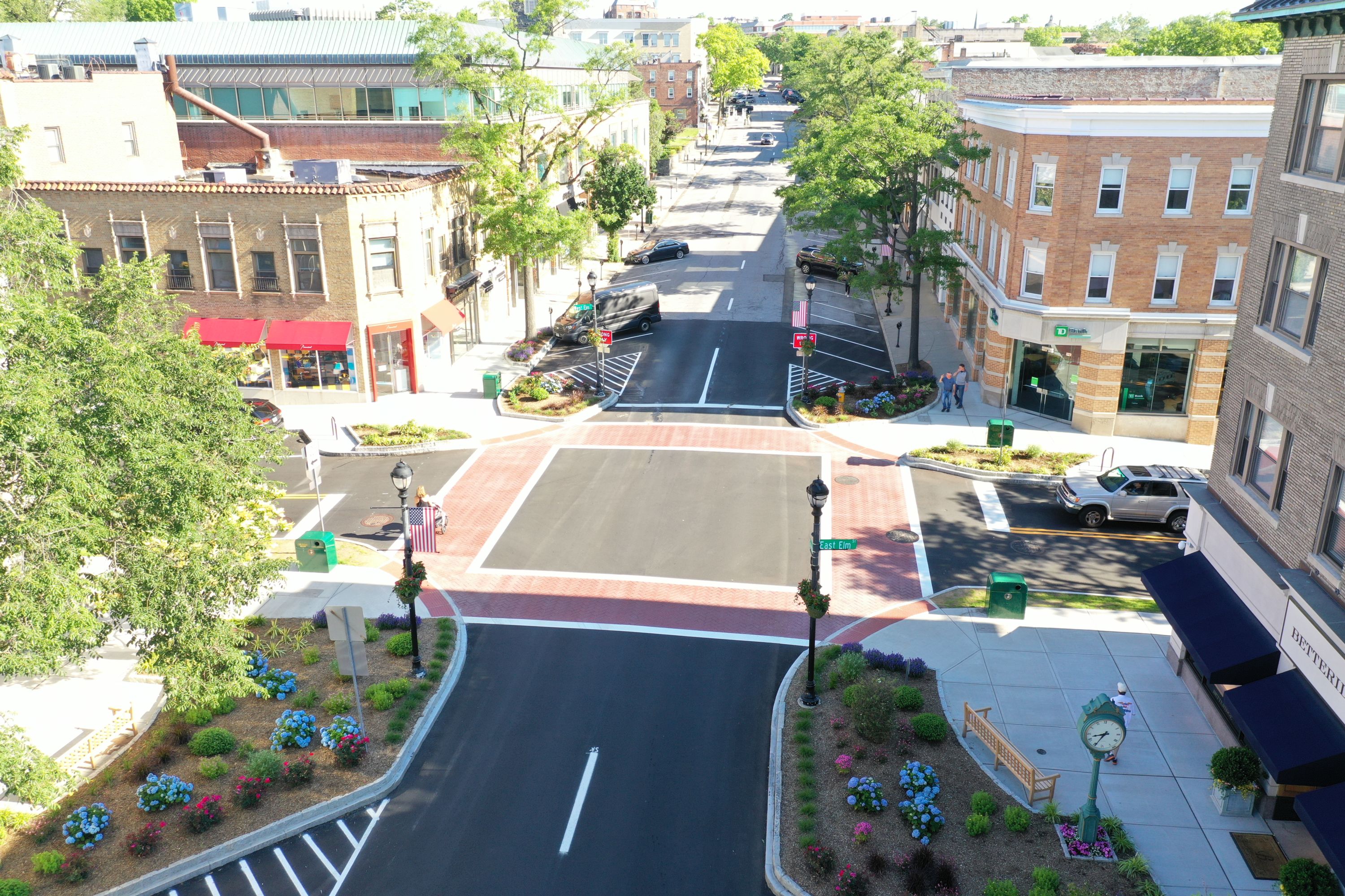
Greenwich Avenue & Elm Street Intersection Improvement Project, Town of Greenwich, CT, U.S.
Town of Greenwich Department of Public Works Deputy Commissioner James W. Michel, P.E.; Senior Civil Engineer Jason Kaufman, P.E.; Town of Greenwich Office of the First Selectman Fred Camillo
After police officers were no longer directing traffic at the Greenwich Avenue and Elm Street intersection, Town of Greenwich Department of Public Works created a complete streets type of design that provides safe and convenient street access for people of all ages and abilities. On a Saturday over 800 pedestrians and 835 vehicles use this intersection in just one hour.The newly installed curb extensions increase the visual connection between the pedestrian and driver, and reduce the crossing time and distance for pedestrians by up to 40 percent. The sidewalks are now widened into the paved roadway which causes motorists to slow down and be more aware of their surroundings. Another safety component is the raised roadway, which improves visibility between pedestrians and motorists, while slowing the speed of vehicles as they proceed through the busy intersection. To provide better illumination for pedestrians, lights were relocated closer to crosswalks.

Pedestrian Safety Improvements at Logan Circle, Washington, D.C.
District Department of Transportation, Mead & Hunt
In August 2021, the District Department of Transportation (DDOT), supported by Mead & Hunt, implemented pedestrian safety improvements at Logan Circle, a complex cluster of eight signalized intersections controlled by a master-two subunit controller configuration. Updated pedestrian Walk + Flashing Don’t Walk intervals were implemented alongside enhanced vehicular clearances in order to “right-size” all clearance intervals.
The work was challenging due to the old interval-based controller firmware, meaning that new intervals had to be created simply to increase clearance values. The controller limitations were complicated by the complex operation of the circle, controlled by 52 vehicle signals and 36 pedestrian signals, and the limitation of an overall cycle length since Logan Circle is within the CBD grid network. These timing changes were made in conjunction with upgrades to signal displays, signing, and markings to improve the safety of the circle for all users, but especially for pedestrians accessing the green space at the center of the circle.
2020 Projects
.jpg)
2019 Vision Zero Action Plan (City of Berkeley, CA)
Every year, nine people are killed or severely injured while walking in Berkeley, an 18 square mile city with 122,000 people. The 2019 City of Berkeley Vision Zero Action Plan recognizes that these tragedies are preventable and adopts a comprehensive approach to eliminate traffic deaths and severe injuries by 2028. Actions were developed through months of coordination with two working groups: 1) a Task Force comprised of key City staff, elected officials, and partner agencies, and 2) an Advisory Committee comprised of representatives from advocacy groups, the public, Berkeley Unified School District, and the City of Berkeley Commissions. This highly collaborative process resulted in an equity-focused, data-driven Action Plan that supports pedestrian safety. Example actions include establishing a Vision Zero Rapid Response Safety Project Protocol to identify quick-build projects that improve pedestrian safety and prioritizing improvements on high-injury streets where 91% of severe and fatal pedestrian collisions have occurred.
.jpg)
Leading Pedestrian Interval (LPI) Signal Timing Modifications (City of Bellevue, WA)
EWorking with the City of Bellevue, Advanced Mobility Analytics Group (AMAG), Microsoft Research, and Jacobs are employing an integrated, intelligent traffic safety platform to provide deep, AI-assisted video and predictive analytics for identifying potential crash risks and helping eliminate crashes before they occur.
The partnership will assess the safety effectiveness of Leading Pedestrian Interval (LPI) signal timing modifications implemented at twenty intersections. The focus on advanced technology and partnerships is integral to Bellevue’s Safe Systems approach to Vision Zero which leverages conflict analytics to identify areas of potential risk, select appropriate safety countermeasures, and monitor outcomes. This analysis will inform decisions on broader LPI deployment.
Success with Vision Zero requires extensive traffic safety experience and methodically proven models facilitated by innovative technology – a challenge welcomed by Jacobs, Microsoft, and AMAG.
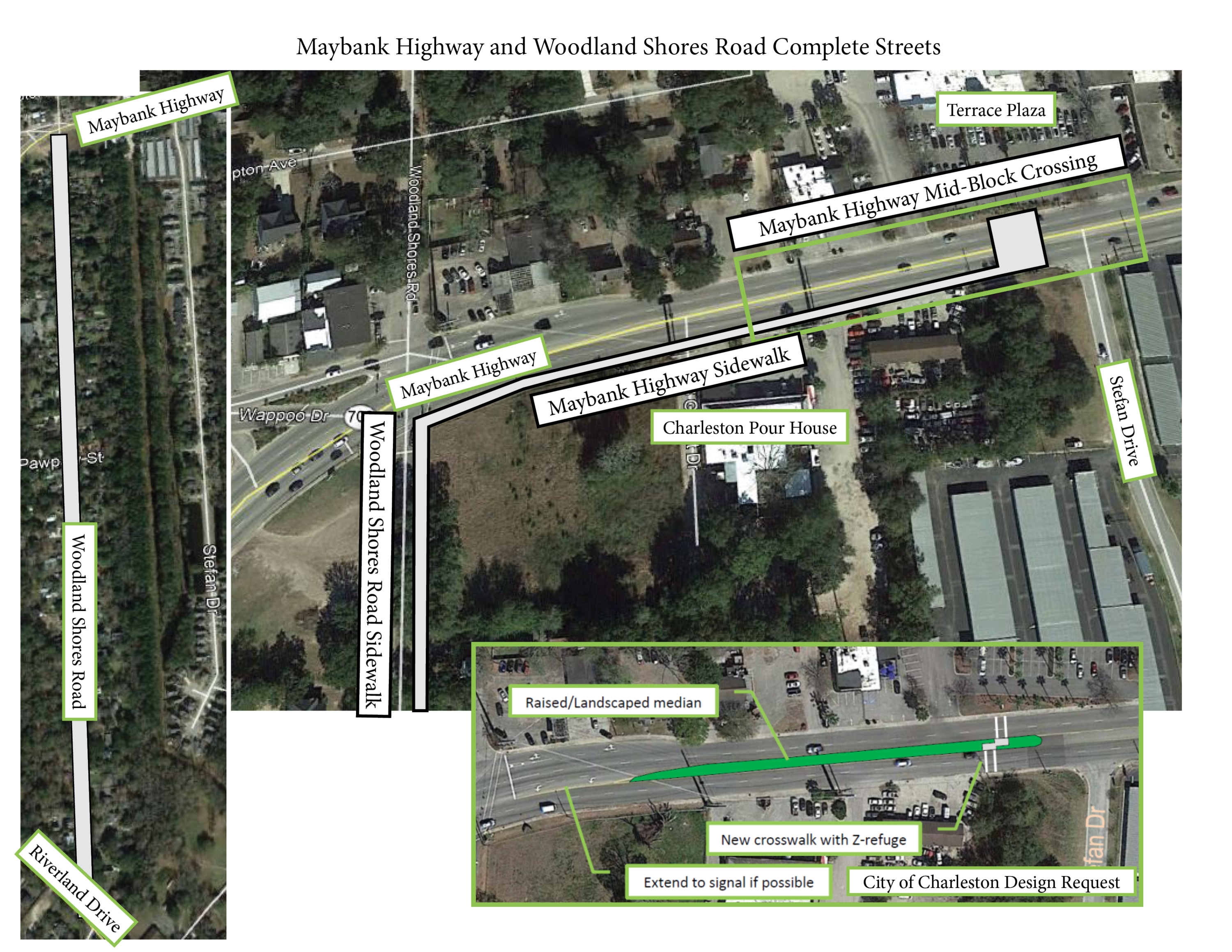
Maybank Highway and Woodland Shores Road Complete Streets (Charleston, S.C.)
The Maybank Highway and Woodland Shores Road Complete Streets project includes installation of an 8-foot sidewalk and a crosswalk on Maybank Highway, an arterial highway with an estimated average annual daily traffic count of 30,700. Charleston County recognized the importance of improving the corridor due to pressing safety issues. A busy shopping plaza and music venue that hosts weekly farmers markets are located on opposite sides of Maybank Highway. Pedestrians often cross this highway to access these businesses, and currently there is no safe crossing. Although residential neighborhoods surround both of these local businesses, the area lacks facilities allowing residents to safely walk or bike to this commercial area. The installation of a sidewalk on Woodland Shores Road will include piping a ditch to help address known drainage issues and provide the needed connection for residents. The County received funding for this project through the local metropolitan planning organization.

Lockwood Drive at Beaufain Street Improvements (Charleston, S.C.)
The Lockwood Drive at Beaufain Street Improvements project includes addition of a crosswalk and median within the left travel lane beyond the intersection of Lockwood Drive and Beaufain Street. There is a sidewalk to the north of the intersection and a multi-use path to the west. This project extends the median to create a forced left turn and dedicated single through lane. These improvements along a major downtown arterial will provide traffic calming for vehicles approaching a sharp curve on Lockwood Drive. Those crossing on foot can now take refuge at the extended median. The crosswalk improves safety and connects the adjacent neighborhoods to major pedestrian and bicycle amenities in the downtown area.
.jpg)
Vision Zero Innovation Program (City of Boulder, CO)
Traditional safety projects have a high cost and can take significant time to implement. To address this, the City of Boulder Transportation & Mobility Department started the Vision Zero Innovation Program to install innovative, quick-build safety treatments on high-risk streets. The program’s three treatment types include curb extensions, pedestrian and bicyclist crossing treatments, and traffic-calming elements. The first treatment installed was a series of curb extensions located next to an elementary school. These shorten pedestrians’ crossing distance by physically narrowing the roadway with flexible delineators and slow turning vehicles by modifying the corner radius. Staff plans to gather both quantitative data (traffic speeds, school zone compliance) and qualitative data (via an online questionnaire, neighborhood outreach) from the community to assess the projects’ effectiveness and build the city’s Vision Zero toolbox.

Pedestrian Safety Improvement Project at Bankhead Elementary School (Kelowna, BC)
The following pedestrian safety improvement project was performed in Kelowna BC, Canada, at Bankhead Elementary School. The project was performed to increase crosswalk safety for students walking to school. Safety was improved by providing a protected waiting area behind the crosswalk, reducing the crossing distance, and increasing sightlines. Speed reduction was also achieved by narrowing the travel lanes at the crosswalk and reducing the curve radius to slow down turning vehicles. This project piloted the use of traffic calming curbs in lieu of concrete curb, which were designed by the City of Calgary. Because the project was recently installed, no follow up data has been collected, however, the design follows the traffic calming principles outlined by the Transportation Association of Canada.

Safe Routes to School Initiative (City of Surprise, AZ)
Y2K Engineering (Mesa, AZ) was proud to assist the City of Surprise, AZ with their Safe Routes to School initiative. In five separate studies, Y2K assessed each school’s infrastructure, initial design of on-site circulation, and staff and crossing guard presence during drop-off and pick-up. Recommendations included enhanced pedestrian crossings, speed mitigation, and strategies to improve drop off and pick up procedures. Walking and biking maps were created for all public elementary schools in the City. These studies created awareness of the six E's and supported grant applications for infrastructure implementation. The scope of the project required collaboration between the Y2K team, city officials, the school district, elementary school principals, staff, teachers, parents and students.
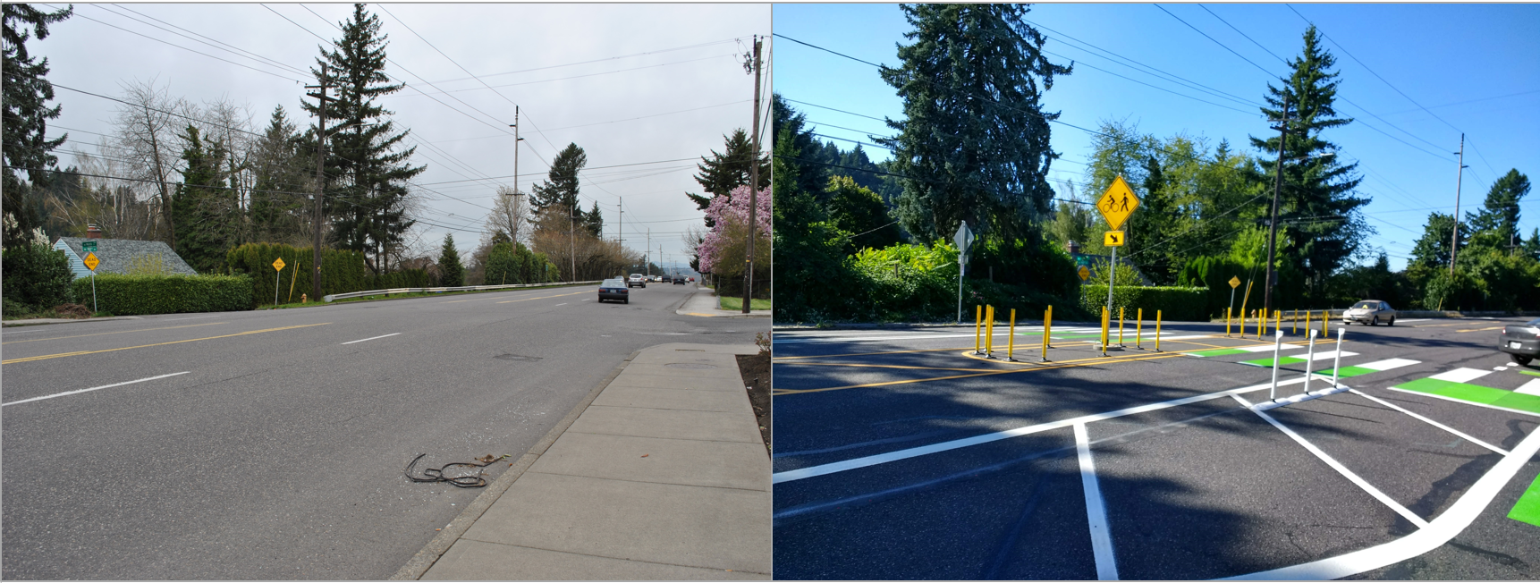
Pedestrian Safety Pilot Program (City of Portland, OR)
Last year, the City of Portland completed a pilot project on a 2-mile segment of NE 102nd Ave from NE Weidler St to NE Sandy Blvd to improve pedestrian safety on one of its high-pedestrian collision corridors. The project had a limited budget so the scope included a five-lane to three-lane road reorganization to permit marking new crosswalks with paint & post refuge island at regular intervals without expensive enhancements like beacons. The pliot included interim paint and post curb extensions and also implemented bike lanes. With the pilot deemed a success, PBOT is currently in the design stage of a follow-up project to make the interim islands permanent and install required ADA improvements. Construction on the permanent project is expected to begin this fall.

Coachman Intersection Improvements (Pinellas County, FL)
Intersection improvements to optimize traffic operations, minimize congestion and enhance mobility for drivers, pedestrians and bicyclists were completed in summer 2020 at NE Coachman Road (SR 590) and Old Coachman Road (CR 525) in Clearwater, Pinellas County. Roadway widening and the addition of left turn lanes on each of the four intersecting roads with a flashing yellow arrow will help maintain consistent traffic flow of the 15,000 daily motorists. Added bike lanes, safety rails, and ADA-compliant sidewalks provide connectivity to the Pinellas Duke Energy Florida and Ream Wilson Trails. This connection will be part of the 75-mile Pinellas Trail loop that extends from north to south county and is enjoyed by 10,000 monthly users. A CSX railroad line that bisects the intersection and the trail path required a unique design to mediate safety requirements and force trail users to slowdown, dismount from their bike and walk across the track.

Pedestrian Safety Intersection Lighting Retrofit (Florida DOT)
Most pedestrian-involved crashes resulting in serious injuries and fatalities in Florida occur during non-daylight hours. As part of our vision to achieve a fatality free transportation system, FDOT issued a 5-year, $100 million statewide intersection lighting retrofit initiative to improve roadway illumination levels and nighttime visibility of pedestrians at over 2,000 intersections.
FDOT used a data-driven approach to identify this significant crash trend, along with the specific corridors that experience the highest frequency of nighttime pedestrian crashes. Funding and guidance were released in 2016 to optimize horizontal and vertical lighting levels for pedestrian visibility from motorists’ perspective. Existing lighted intersections were upgraded from high pressure sodium lights to LED, while unlit intersections received new LED lighting. Construction of the geographically clustered project bundles will be complete in 2021.
FHWA reports that improving intersection lighting at intersections should reduce nighttime pedestrian fatalities that occur in these locations by up to 78%!
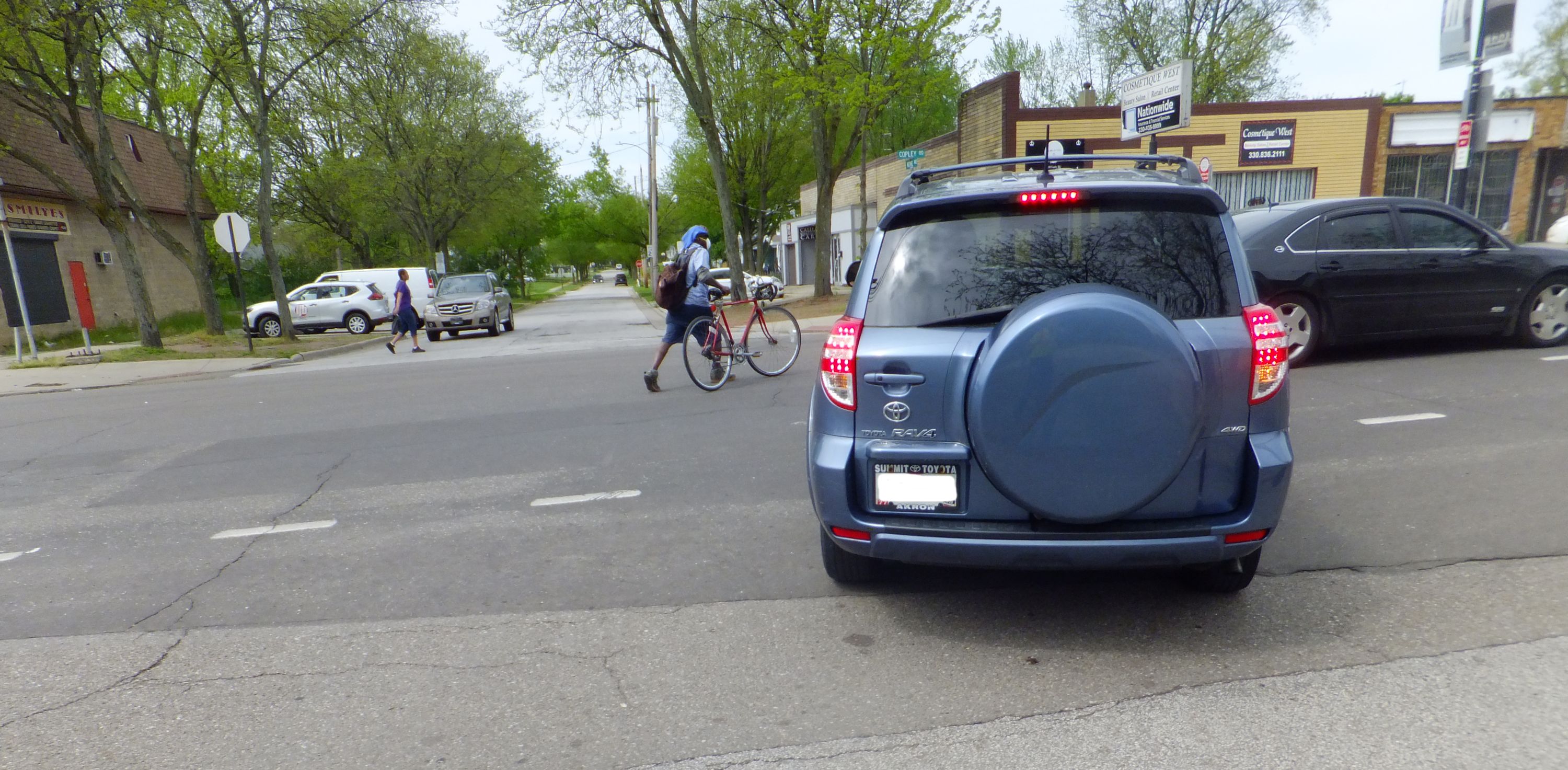
Pedestrian Safety Improvement (Ohio DOT)
After fatal pedestrian crashes in Ohio increased 60% over the last decade, the Ohio Department of Transportation (ODOT) developed the Pedestrian Safety Improvement Program (PSIP), which provides $10M in funding to address the issue. ODOT hired LJB Inc. to help develop pedestrian crash countermeasures, provide guidance on the applicability of those countermeasures to specific conditions, and assist cities in selecting locations and countermeasures.
The team designed improvements to 528 locations in eight large Ohio cities, using 23 different safety solutions, including curb bump outs, curb ramps, signing and marking, overhead sign supports, RRFBs, PHBs, and street lighting.
The program streamlined the typical project development process by batching the environmental documents by District, managing utility risk within both the design and construction phases, and utilizing biddable construction plan formats. These time-saving approaches have allowed the program to support bidding all projects in early 2021.

Bagley Street (Detroit, MI)
Bagley St. in Southwest Detroit is known locally as Mexicantown due to its large Mexican population. Bagley has long been an attractive destination in Detroit. The street is lined with restaurants, shops, bakeries and a busy tortilleria. The narrow street is frequently used by vehicles, pedestrians and cyclists. In 2019 the City of Detroit reconstructed Bagley to ensure the safety for all street users and promote a walkable street. Project efforts include a curb-less street with raised intersections to control speeds coming onto the street and using decorative bollards to protect those waiting to cross. Working with the community, goals of the project were to create beautiful, plaza like street, reflecting on Mexican heritage from festive “tile-like” jointing pattern to the use of purple, blue and yellow accent pavers. Today, Bagley continues to be a celebration of Mexican culture and an even more pleasant place to walk and shop.
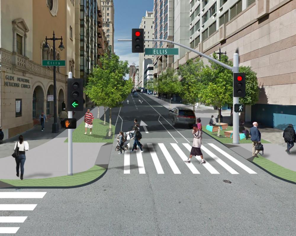
Safer Taylor Street Project (San Francisco, CA)
The San Francisco Municipal Transportation Agency (SFMTA) recently completed near-term components of the Safer Taylor Street Project, bringing traffic safety improvements to vulnerable road users on one of the Tenderloin district’s most high-conflict streets. Pedestrian improvements installed included a vehicle travel lane reduction, a wide loading lane, generous parking buffers, signal timing changes, new left turn signals, and Painted Safety Zones throughout corridor.
An evaluation of the countermeasures demonstrated significant improvements to the street. Vehicles traveling over 30mph decreased by 31% and vehicles traveling over 40 mph decreased by 94%. At one of the new left turn signals, the number of vehicles yielding to pedestrians during the morning peak increased by 58% and close calls dropped from 14 to 0. Overall, the number of vehicles yielding to pedestrians increased by an average of 25% at intersections where changes were made.
%20credit.png)
Broad Street Corridor Pedestrian Safety Improvements (Stamford, CT)
The City of Stamford, the fastest growing municipality in Connecticut, is evaluating innovative pedestrian safety improvements for the Broad Street Corridor that enhances the environment for downtown residents, workers, business owners, and visitors while responding to evolving transportation modal choice, travel demand, and social distancing needs driven by the COVID-19 public health crisis. The City has selected AKRF as the design consultant for our innovative approach to incorporate green infrastructure, flexible open space, and smart traffic signal infrastructure to reduce the number and severity of crashes based on historic priority locations while improving the pedestrian experience linking two Central Business Districts along the Broad Street corridor from Atlantic Street to Greystone Place. This project is being conducted through the State of Connecticut’s Local Road Accident Reduction Program, which provides federal funding for safety-related improvements on local roads.
.jpeg)
Solar Solution for a Shady Solution (Vancouver, BC)
Vancouver, BC may be Canada’s third largest city, but when it comes to walkability, it’s far and away number one. That’s according to data from Walk Score, which recently awarded the picturesque westcoast city of 2.5 million a score of 80/100, meaning it’s “very walkable,” and “most errands can be completed on foot.”
Though it’s easy to attribute Vancouver’s status as an eminently walkable city to its mild climate, natural beauty, and lively neighbourhoods, a more important factor is the investments the City has made in infrastructure that encourages walking and other forms of active transportation. This has included the implementation of greenways, pedestrian-only zones, and accessibility improvements like curb ramps and audible pushbuttons.
Another initiative they have undertaken in recent years is the installation of rectangular rapid-flashing beacons (RRFBs), an alternative to traditional flashing beacons that use high-intensity flashing LED lights to capture drivers’ attention and increase yielding at uncontrolled crosswalks. In 2016, the City
began testing them at three crosswalk locations, selected for their large pedestrian volumes and low yield rates.

Advisory Bike Lanes (Town of Vail, CO)
This past summer the Town of Vail installed Advisory Bike Lanes (ABL’s) along a portion of Vail Valley Drive which is a narrow residential road that also is a part of the very popular Gore Valley Trail, carrying over 1300 bicyclists and 250 pedestrians per day. ABL’s are striped shoulder bike lanes that allow for two-way vehicular traffic to share a narrowed single center lane while pedestrians and bicyclists utilize the ABL’s striped on each side. The ABL trial consisted of a center vehicle drive aisle of 11’ and two ABL’s of 5’ in width. The Town received overwhelming positive feedback, with over 90% compliance of pedestrians and bicyclists using the ABL’s correctly which allowed vehicles and buses to pass by safely. The Town of Vail used www.engagevail.com to educate users and receive feedback, as well as facebook feedback, and in person drive by surveys, and compliance counts.

Hart Branch Trail (Town of Little Elm, TX)
The Town of Little Elm, Texas near Lewisville Lake recently enhanced its Harts Branch Trail, a 12-foot-wide, 1.3-mile shared-use trail meandering along the Harts Branch riparian corridor. The trail safely links the Town’s neighborhoods, businesses and communities to a 70-acre greenway and a larger regional trail network.
The project’s primary goals were to facilitate trail and roadway intersection safety, alleviate flooding issues and increase micromobility connectivity and alternative mobility. An important element of the trail is the crossing at Walker Lane (pictured), which prioritizes pedestrian safety with a wide crosswalk, visible signage and rapid-flashing beacon systems.
Halff, a prestigious E/A firm with offices throughout the Southeast, was responsible for completing the site analysis, public involvement, linear park master plan components, cost estimates and public presentations to Little Elm staff and area stakeholders. The trail was built in coordination with TxDOT using Transportation Alternatives Program funding awarded by NCTCOG

Pedestrian Action Safety Plan (Virginia DOT)
The Virginia Department of Transportation (VDOT) created its first statewide Pedestrian Safety Action Plan (PSAP) in 2018. It is now a national model for rapid plan development and delivery of safety projects.
Pedestrian safety is a major concern in Virginia. Between 2014 and 2018, more than 500 pedestrians died and over 8,000 were injured while walking along or across Virginia’s public roads.
Led by a stakeholder team, the Pedestrian Safety Action Plan evaluated all public road segments in Virginia to identify locations with a history of or potential for pedestrian safety concerns. VDOT reported its findings and shared the online mapping tool with agency staff and local partners to introduce the priority pedestrian corridors and crash clusters in their area. The publicly available mapping tool can be viewed online at https:/bit.ly/VDOTPSAP_V2.
VDOT is currently funding more than $30 million in pedestrian safety projects at plan-identified locations.

Walkability Study (Johnston, IA)
The Johnston (Iowa) Walkability Study gathered input from city departments, a steering committee, stakeholder groups, and the public to identify infrastructure improvements and priorities, establish best practices for pedestrian facilities, ensure that crossings maximize pedestrian safety, and consider maintenance needs and abilities.
The pedestrian network analysis reviewed current conditions, school walk zones, crash records, and stakeholder input to identify deficiencies. Recommendations were broken down into high, medium, and low urgency based upon safety concerns, ADA-compliance, connectivity, or aesthetics.
The study also recommended amending the City’s ordinances regarding traffic calming, traffic engineering, subdivisions, site plans, complete streets, sidewalks, and maintenance to support a more pedestrian-friendly community.
The City has been improving several pedestrian crossings in accordance with the implementation plan, focusing on infrastructure that was identified as a safety or ADA concern. Some of these crossings were completed in conjunction with trail projects that were also identified as priority connections.

Be Safe Be Seen Pedestrian and Bicycle Safety Initiative (Waco, TX)
The TxDOT Waco District’s BE SAFE BE SEEN Pedestrian and Bicycle Safety Initiative seeks to increase awareness and share resources about pedestrian and bicyclist safety. This is imperative as I-35 is reconstructed adjacent to Baylor University.
The initiative has six goals:
- Increase awareness and outreach about the shared responsibility of drivers, bicyclists and pedestrians to keep themselves and others safe on Waco-area roads
- Implement proactive communication and outreach with those most directly impacted by the reconstruction project
- Develop a model for information sharing
- Partner with local agencies and businesses to conduct outreach
- Design tools and products useful for diverse audiences
- Evaluate program effectiveness
The initiative implemented several tactics to improve safety:
- Enhancement to a real-time map to include information specifically for pedestrians, I-35 Waco Project 4B real-time map
- Wayfinding pavement decals
- “No Pedestrian Crossing” stencils on barriers in the construction areas
- Additional signage, barriers and fencing to guide foot and bike traffic on designated, open paths Be Safe Be Seen pavement decals installed QR code sends pedestrians to online crossing diagram

Citywide Signal Timing Optimization Program (Washington, D.C.)
The District Department of Transportation (DDOT) conducts large-scale annual traffic signal improvements via the Citywide Signal Timing Optimization Program. One focus area of this program is improving pedestrian safety and multimodal mobility for users of all ages through signal timing and operational changes. Over the past two years, DDOT has implemented over 450 new Leading Pedestrian Intervals across the city, bringing the citywide LPI total to over 650 intersections, with 200+ additional locations planned for Fall 2020. Along with LPIs, DDOT has implemented half-cycles where feasible to reduce pedestrian wait times and increase crossing opportunities, pretimed up to 85% of its traffic signals to provide consistent and reliable crossings, increased crossing times near Age-Friendly destinations, and implemented phasing improvements at key intersections to time-separate pedestrian crossings. As part of the District’s Vision Zero Initiative, DDOT is committed to implementing these improvements that prioritize pedestrian safety and mobility at signalized intersections.

5 Street S.W. Underpass Enhancements (Calgary, AB)
The 5 Street S.W. underpass provides a direct north-south connection for people who live, work and shop in Downtown Calgary and the city’s Beltline area.
The City of Calgary’s vision is to transform an ordinary space into an extraordinary experience, supported by three goals:
- improve options for travelling around downtown
- provide safe and comfortable connections, and
- improve the look and feel of the current underpass.
The inclusion of safety features is of utmost importance, including:
- wider sidewalks and upgraded, accessible crosswalks
- improved lighting by significantly increasing the number of streetlights and underpass lights
- security cameras and help phones
- urban braille down the center of the sidewalk, and
- larger pedestrian waiting areas at the intersections.
These enhancements not only greatly improve the underpass, but also integrate public art into the design. This project is part of a broader underpass enhancement program from The City that improves the safety and comfort of pedestrians and cyclists.

Estero Boulevard (Fort Myers Beach, FL)
Estero Boulevard is a two-lane main road running the length of Fort Myers Beach, Florida. Previously, Estero Boulevard had a continuous two-way center turn lane with minimal or narrow sidewalks lined with shops, motels and restaurants. From 2010 through 2014, 30 pedestrian and bike crashes (6 per year) were reported in the first mile of Estero Boulevard.
In 2016, Estero Boulevard was rebuilt with curbing to control parking in the right-of-way, wider sidewalks and improved pedestrian crossings. Pedestrian crossings at busier location include Rectangular Rapid Flashing Beacon (RRFB) signage and serpentine neck-downs near bus stop locations. From 2017 through 2019, 12 pedestrian and bike crashes (4 per year) were reported. Pedestrian and bike crashes on Estero Boulevard have been reduced from 6 per year to 4 per year.
%20main%20street.jpg)
Montgomery (Bowness Road) Main Street Project (Calgary, AB)
The Bowness Road Main Street project envisions a family-friendly, vibrant, and safe street designed to meet the needs of local business and residents as well as attracting private investment into the community. The design was developed through extensive community engagement, and construction started this year.
The project is transforming Bowness Road from a vehicle centred collector roadway corridor to a pedestrian friendly, sustainable and multi-modal neighbourhood “complete street” through widened sidewalks, dedicated cycling facilities, landscape improvements, on-site stormwater mitigation, and pedestrian oriented lighting improvements.
Pedestrian comfort and safety will be significantly improved through: curb extensions that reduce pedestrian crossing distances and increased visibility, Rapid Rectangular Flashing Beacons (RRFB), and reduced vehicular lane widths to reduce travel speeds.
Once complete, Bowness Road Main Street will serve as a precedent for transportation retrofit projects, transforming roadways into community-friendly streets that attract both businesses and residents.
.jpg)
US Highway 49 (Gulfport, MS)
City of Gulfport requested that we evaluate the pedestrian circulation and high fatality rate of pedestrians along US Highway 49 in the 1 mile corridor between Creosote Road and Turkey Creek in Gulfport, MS. Several pedestrians have been struck by vehicles along this route and injured or killed. An evaluation of the available right-of-way, existing lane geometry, adjacent land uses/driveways, pedestrian activity and potential mitigation options was conducted.
US Highway 49 presents a major obstacle to bicycle and pedestrian movements, as the roadway has six thru lanes (108 ft width). The analysis evaluated the existing vehicular and pedestrian traffic and identified recommendations to modify the existing right-of-way/lane geometry to better accommodate pedestrians.
Multiple phases of recommendations included:
1) Crosswalks/ped heads/push buttons/islands/lighting,
2) Construction of multi-use path,
3) Pedestrian Hybrid Beacon, and
4) Median Barrier construction.